1902 Encyclopedia > Hadrian's Wall (Wall of Hadrian)
Wall of Hadrian. It is under this heading that it seems cost convenient to give a short account of the stone wall and other works erected by the Romans in the north of England between the Solway and the Tyne, and commonly known as the Roman Wall. As will be afterwards seen, those who have written on the subject are by no means agreed that the name of Hadrian ought to be exclusively associated with this great fortification. But before touching on the question, it is necessary to describe the works themselves.
Hadrian's Wall, built by the legionaries of the Roman Emperor
Hadrian to separate England and Scotland. The wall stretches from one
coast of Britain to the other and is 73 miles long.
Viewed as a whole the Roman wall, when entire, consisted of three parts: - (1) a stone wall, strengthened by a ditch or fosse, at a short distance from its northern base; (2) three parallel earthen walls, with a ditch sloping down from the northern side of the second of these lines; (3) stations, castles, and turrets, placed at various intervals for the accommodation of troops, and communicating with one another by a military way.
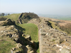
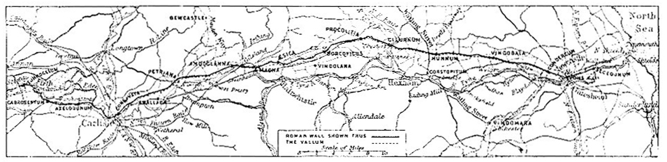
The Murus or stone wall extended from Wallsend on the Tyne to Bowness on the solway firth, a distance of fully 73 English miles. No portion of it now remains as when finished, so that its original height cannot be accurately determined. Bede gives 12 feet, an estimate that our chief modern authority on the Wall, Dr. J. Collingwood bruce, deems to low, for some parts of its course at least. Its thickness varies, being 6 feet in some places and 9 _ in others.
Plan of Hadrian's Wall
The northern face of the wall was continuous, but the southern had numerous outsets and insets, as if portions of the work had been carried on at the same time but without definite instructions as to a uniform breadth. In this way when sections met differences in width often showed themselves, though the junctions was so managed that the irregularity was confined to one face. It is not improbable that a similar discretion was allowed as regards height. Both sides consisted of blocks of freestone 8 or 9 inches thick, 10 or 11 broad, and from 15 to 20 long. These has been sometimes quarried near the spot, sometimes brought from considerable distances. The interior was filled with rubble firmly cemented with mortar of a peculiar tenacity. In pursuing its course from sea to sea, the Wall seldom deviated from the shortest and straightest course it could follow, and then only with the evident design of seizing neighboring elevations that would otherwise have commanded its position. Along the whole length of its northern base, and adding greatly to its strength as a defensive work, was drawn a ditch or fosse of varying breadth and depth, East and West, and is supposed to have been compiled in the beginning of the 5th century of our era, there were 23 such stations. The names given areas follows: - Segedunum (Wallsend), Pons Aelii (Newcastle), Condercum (Benwell Hill), Vindobala (Rutchester), Hunnum (Halton Chester), Cilurnum (Chesters), Procolitia (Carrawburgh), Borcovicus (Housesteads), Vindolana (Chesterholm), Aesica (Great Chesters), Magna (Carvoran), Amboglanna (Birdoswald), Petriana, Aballaba, Congavata, Axelodunum, Gabrosentum, Tunocelum, Glannibanta, Alionis, Bremetenracum, Olenacum, and Virosidum. It is somewhat strange that not a trace of one of these names survives in the local vocabulary of the present day, though the exact positions of a number of the stations have been identified beyond all doubt by other means. the sites had been chosen with great care, and much labor must have been expended in their construction. They were in fact military cities, "suited," to use the words of Dr Bruce, "to be the residence of the chief who commanded the district, and providing secure lodgment for the powerful body of soldiery he had under him." It is not clear, however, that more than 18 of the 23 were situated per lineam valli, the others being probably supporting stations. The Wall was further strengthened by quadrangular buildings called mile-castles as well as by smaller watch-towers or sentry-boxes of stone; while connecting the whole was a military way made in Roman fashion and protected by the other parts of the fortification. By means of this road the garrisons of the different stations 36 and 15 feet respectively being probably its average dimensions. In some places the difficulties to be overcome by its excavators, owing to the rocky nature of the soil, must have been enormous in an age when blasting with gunpowder was unknown. But none of them have been shunned.
South of the Murus ran the earth wall or Vallum, consisting, as has been already stated, of three ramparts and a ditch. Of these mounds the most northerly was raised at a distance from the base of the stone wall varying, according to the nature of the country, from 30 yards to half a mile. Time and the spoiler have dealt so hardly with it that it original dimensions cannot now be accurately stated. It seems, however, to have been about 20 feet broad at the base and at least 10 feet high. The materials of which it was made up consisted of earth largely intermixed with fragments of stone of all sizes and shapes. 24 feet or so further south was ditch apparently somewhat inferior in breadth and depth to the ditch of the Murus, though otherwise of the same character. On its southern edge was a rampart much smaller in size than the one just noticed, while the series was completed by a third mound, approaching in its dimensions the larger of the other two, and raised at nearly the same distance it from the center of the included ditch.
Along the wall, at intervals averaging 4 miles, were stationary camps strongly fortified. According to the Notitia Utriusque Imperii, which contains a brief record of the civil and military arrangement of the empires of the could be quickly and safely concentrated on any point along the line that was threatened by an enemy. "It is sometimes asked," remarks the authority just quoted, "How long would the Wall be in building? From calculations that have been made, founded upon the experience gained by the construction of the vast works connected with modern railways, it is considered that, in the existing circumstances of the country at the time, the Vallum and the Murus could not be reared in a shorter period than 10 years. The cost of it in our present currency would be about 1,000,000 pounds. Above 10,000 men would be required to garrison its stations" (Wallet, Book of the Roman Wall, p. 37).
Several of the ancient writers allude to ramparts and lines of forts raised by the Romans across the island during the time they had a footing in it. Of these notices some refer to the barrier on the isthmus of the Forth and Clyde (see Antoninus, Wall of , vol. ii. p. 139); the others probably apply to the more important works now described. In this Agricola Tacitus states that the Roman general during his operations in the north of England (79 A.D.) compelled many states hitherto hostile to lay down their arms and surrounded them with garrisons and castles. A hundred years later two contemporary historians, Dion Cassius (as abridged by Xiphilline) and Herodian, writing of events in Britain that occurred in their own day, both notice-the former in two places-the existence of a wall in Britain, separating the Roman territory from the unconquered tribes that dwelt beyond; but neither of them mentions when or by whom it was built. Another century onwards and Spartian, one of the Scriptores Historioe Augustoe, states that the emperor Hadrian was the first to rear a wall across Britian (circa 120 A.D.) as a defense against the northern barbarians. It was, he adds, 80 miles in length. The same author in his life of Severus tells us that emperor also raised a wall from sea to sea (circa 208 A.D.). Aurelius Victor, who flourished about the year 360 A.D., ascribes to Severus the building of a wall in Britain, employing almost the words of Spartian; while his con temporary, Eutropius, makes a similar statement, adding, however, that this rampart was 32 (according to another reading, 132) miles long, and erected for the defence of certain portions of the country, which Severus had reconquered for Rome. Another possible wall-builder is introduced to us in the early years of the 5th century by the poet Claudian, who represents Britain as indebted to stilicho, the successful general of the emperors Theodosius I. and Honorius, for some protection of this nature against the attacks of the Scots, Picts, and Saxons. Lastly, Gildas, our earliest native historian, asserts that the Britons themselves built a wall to aid them in warding off the assaults of the Picts and Scots, and that another was constructed by the Romans with native assistance, just before their final abandonment of the island. Both statements are repeated by Bede, who identifies the former of these structures with Antonine’s wall and the latter with the more famous fortification near his own monastery of Jarrow. Founding on such unsatisfactorily of not conflicting data, modern writers have been led to give various answers to the questions-When and by whom was the Roman Wall built? The limits of the present article do not admit of any discussion of the subject, and those who wish to see these questions fully examined, as well as to read account of the inscriptions and other antiquities discovered from time to time along the line of the Wall, are referred to the list of works given below, more especially to Dr J.C. Bruce’s exhaustive treatise. For others the following summary may be sufficient.
Gordon, to whom we owe one of the earliest surveys of the Wall, is of opinion that the Vallum was the work of Hadrian, and the Murus of Severus. Horsley believed that the stations and the northern rampart of the Vallum were raised by Agricola, the ditch of the Vallum and its remaining mounds by Hadrian, and the stone wall with its castles, towers, and its great military way by Severus. Dean Merivale, while admitting that camps and mounds may have been erected on the isthmus by Hadrian and Severus, supposes that the stations were faced with masonry and the work planned as well as partly executed by Theododius, his designs being afterwards fully carried out about 400 A.D. by Stilicho, in orders issued from Gaul. But others, and foremost among them Dr Bruce, see in the fortification a unity of design that points it out as the work of one period and one mind, and have come to the conclusion that Hadrian was the builder of the whole. This view, as it does not exclude the probability that his engineers worked to some extent on lines already laid down by Agricola, and that Severus, before entering on his unfortunate campaign against the Caledonians, or after its close, repaired and strengthened the works of his predecessors, seems most consistent with the statements of ancient writers, with the testimony of inscriptions, and with the appearances presented by the relative position of the component parts of the fortification itself.
See Gordon’s Itinerarium Septentrionale, London, 1727; Horsley’s Britannia Roana, London, 1732; Hutton’s History of the Roman Wall, London 1813; Hodgson’s Roman Wall, &c., Newcastle, 1841; McLauchlan’s Survey of the Roman Wall, made in the years 1852-54; Bruce’s Roman Wall, 3d, ed., London, 1863. (J. McD.)
The above article was written by James Macdonald, M.A., LL.D.; Vice-President of the Society of Antiquaries of Scotland, 1895-97; Rhind Lecturer on Archaeology, 1897; author of Tituli Hunteriani: an Account of the Roman Stones in the Hunterian Museum.
|