1902 Encyclopedia > Aqueduct > Aqueducts of Later Roman Empire: Spoleto; Constantinople.
Aqueduct
(Part 7)
Aqueducts of Later Roman Empire: Spoleto; Constantinople
The aqueduct near Spoleto, which now serves also as a bridge, is deserving of notice as an early instance of the use of the pointed arch, belonging as it does to the 7th or 8th century. It has ten arches, remarkable for the elegance of their design and the airy lightness of their proportions, each over 66 feet in span, and about 300 feet in height. (See Plate IV.)
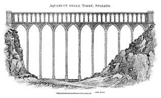
Aqueduct delle Torre, Spoleto, Italy
The aqueduct of Pyrgos, near Constantinople (figured on Plate III.), is a remarkable example of works of this class carried out in the later times of the Roman empire. It consists of two branches, of which only one is seen in elevation on the plate. The other branch stood nearly at right angles to this, and is seen partly on the plan. From this circumstance it was called the Bended or Crooked Aqueduct, to distinguish it from another termed the Long Aqueduct, situated near the source of the waters. The branch seen in elevation extends 670 feet in length, and is 106 feet in height at the deepest part. It is composed of three rows of arches, those in each row increasing in width from the bottom to the top-an arrangement very properly introduced with the view of saving materials without diminishing the strength of the work. The two upper rows consisted of arches of semicircles, the lower of Gothic arches; and this circumstance serves to fix the date of the structure, as these last were not introduced until the 10th century. The breadth of the building at the base was 21 feet, and it diminished with a regular batter on each side to the top, where it was only 11 feet. The base also was protected by strong buttresses or counterforts, erected against each of the pillars. The other branch of the aqueduct was 300 feet long, and consisted of twelve semicircular arches.
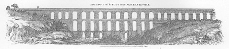
Aqueduct of Pyrgos, near Constantinople (Istanbul, Turkey)
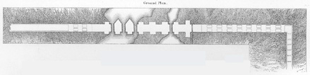
Ground Plan of Aqueduct of Pyrgos, near Constantinople (Istanbul, Turkey)
This aqueduct serves to convey to Constantinople the waters of the valley of Belgrade, one of the principal sources from which the city is supplied. These are situated on the heights of Mount Haemus, the extremity of the Balkan Mountains, which overhangs the Black Sea. The water rises about 15 miles from the city, and between 3 and 4 miles west of the village of Belgrade, in three sources, which run in three deep and very confined valleys. These unite a little below the village, and then are collected into a large reservoir. After flowing a mile or two from this reservoir, the waters are augmented by two other streams, and conveyed by a channel of stone to the Crooked Aqueduct. From this they are conveyed to another which is the Long Aqueduct; and then, with various accessions, into a third, termed the Aqueduct of Justinian. From this they enter a vaulted conduit, which skirts the hills on the left side of the valley, and crosses a broad valley 2 miles below the Aqueduct of Justinian, by means of an aqueduct, with a double row of arcades of a very beautiful construction. The conduit then proceed onward in a circuitous route, till it reaches the reservoir of Egri Kapan, situated just without and on the walls of the city. From this the water is conducted to the various quarters of the city, and also to the reservoir of St. Sophia, which supplies the seraglio of the grand signior. The Long Aqueduct is more imposing by its extent than the Crooked one, but is far inferior in the regularity of design and disposition of the materials. It is evidently a work of the Turks. It consists of two rows of arcades, the lower being forty-eight in number, and the upper fifty. The whole length was about 2200 feet, and the height 80 feet. The Aqueduct of Justinian is a very excellent work, and without doubt one of the finest monuments which remain to us of the Middle Ages. It consists of two rows of large arcades in the pointed style, with four arches in each. Those of the lower story have 52 feet of span, the upper ones 40 feet. The piers are supported by strong buttresses, and at different heights they have little arches passing through them, which relieve the deadness of the solid pillar. The length of this aqueduct is 720 feet, and the height 109 feet. This aqueduct, though it bears the name of Justinian, was probably erected in the time of Constantine.
Besides the waters of Belgrade, Constantinople was supplied from several other principal sources, one of which took its rise on the heights of the same mountains, 3 or 4 miles east of Belgrade. This was conveyed in a similar manner by an arched channel, elevated, when it was necessary, on aqueduct bridges, till it reached the northern parts of the city. It was in the course of this aqueduct that the contrivance of the souterasi or hydraulic obelisks, described by Andreossy (in his voyage to the Black Sea and account of the Thracian Bosphorus) was constructed, which excited some attention, as being an improvement on the method of conducting water by aqueduct bridges, "The souterasi," says Andreossy, "are masses of masonry, having generally the form of a truncated pyramid or an Egyptian obelisk. To form a conduit with souterasi, we choose sources of water, the level of which is several feet higher than the reservoir by which it is to be distributed over the city. We bring the water from its sources in subterranean canals, slightly declining until we come to the borders of a valley or broken ground. We there raise on each side a souterasi, to which we adapt vertically leaden pipes of determinate diameters, placed parallel to the two opposite sides of the building. These pipes are disjoined at the upper part of the obelisk, which forms a sort of basin, with which the pipes are connected. The one permits the water to rise to the level from whence it had descended; by the other, the water descends from this level to the foot of the souterasi, where it enters another canal under ground, which conducts it to a second and to a third souterasi, where it rises and again descends, as at the last station. Here a reservoir receives it and distributes it in different directions by orifices of which the discharges is known." Again he says, "it requires but little attention to perceive that this system of conducting tubes is nothing but a series of siphons open at their upper part, and communicating with each other. The expense of a conduit by souterasi is estimated at only one-fifth of that of an aqueduct with arcades." There seems to be really no advantage in these pyramids, further than as they serve the purpose of discharging the air which collects in the pipes. They are in themselves an evident obstruction, and the water would flow more freely without any interruption of the kind. In regard to the leaden pipes, again, they would have required, with so little head pressure as is stated, to be used of very extra-ordinary dimensions to pass the same quantity of water as was discharged along the arched conduits. There is something, therefore, which would require explanation in the account Andreossy gives of these pyramids, if, indeed, he did not misunderstand the nature of them.
The other principal source from which Constantinople is supplied, is from the high grounds 6 or 8 miles west of the town, from which it is conducted by conduits and arches, in the same manner as the others. The supply drawn from all these sources, as detailed by Andreossy, amounted to 400,000 cubic feet per day. The charge of the water-works at Constantinople belongs to a body of 300 Turks and 100 Albanese Greeks, who form almost an hereditary profession.
Canals and Basins in Ancient Egypt and Babylonia
In ancient Egypt and Babylonia a different problem of water supply was presented, both countries being flat and traversed by great rivers, from which they were subject to regular inundations. Hence canals with large basins took the place of the aqueducts of Greece and Rome, and the stupendous scale on which in Egypt the waters of the Nile, and in Babylonia the waters of the Tigris and Euphrates, were utilized, was a marvel to ancient travellers.
Read the rest of this article:
Aqueduct - Table of Contents
|