1902 Encyclopedia > Arabia > Arabia - Introduction. Extent of Arabia. Coasts of Arabia.
Arabia
(Part 1)
(1) Arabia - Introduction. Extent of Arabia. Coasts of Arabia.
Sources of Information on Arabia
Our information in regard to the physical character of Arabia must be chiefly derived from the accounts given by European travelers; amongst whom Niebuhr, Burckhardt, Wallin, Welsted, and Palgrave have been on this occasion chiefly consulted; and to their works the reader must necessarily be referred for a variety of details impossible to compress into a summary like the present.
Extent of Arabia
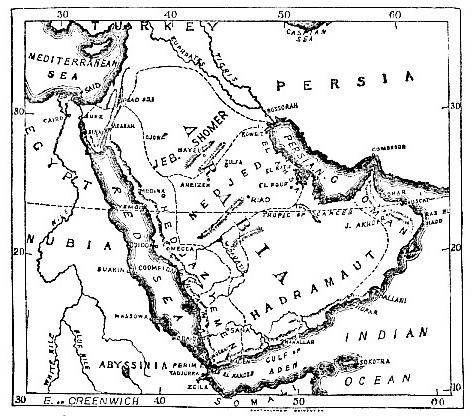
Arabia is a peninsula stretching from north-west to south-east, between 30° and 12° 45’ lat., and between 32° 30’ and 60° E. long. Its form is that of an irregular parallelogram, almost a triangle indeed, bounded on the W., S., and E. by the red Sea, the Indian Ocean, and the Persian Gulf respectively; on the N., where runs its narrowest limit, it joins on to the mainland of Syria. Its correct boundary in this direction would be assigned by a line drawn transversely, west and east, from Suez to the head of the Persian Gulf. But some writers, Burckhardt included, add to this extent all the Syrian desert behind Palestine, and the valleys of the Jordan and Orontes up to the village of Anah, on the Euphrates 34° N. lat.; and then down again by the right bank of that river to where, joined by the Tigris, it takes the name of Shatt-el-Arab, and so to the Persian Gulf again. Roman geographers make Arabia the further present of Mesopotamia; and Abul-Feda, an Aleppine of the 13th century, would even bring its denomination so far north as to include Aleppo. We will, however, accept the first-mentioned as the most correct line of demarcation. According to this, the extreme length of the Arabian peninsula, from the head of the gulf of Akabah to the straits of Bab-el Mandeb would be about 1300 miles; its greatest breadth, in 23° N. lat., from the Red Sea coast, west, to Ras-el-Hadd, east, 1500 miles; and its apex, where it joins on to the continent of Asia, rather under 900 miles.
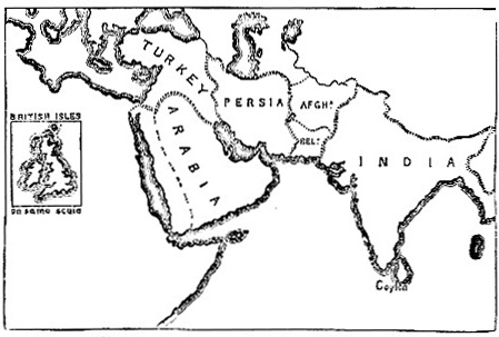
Sketch map, showing relative size of Arabia in relation to neighbouring countries
Western Coast of Arabia
The western coast is washed by the Red Sea. It exhibits a range of low mountains, seldom exceeding 2000 feet in height, abrupt in outline, and generally barren; between them and the sea is a narrow and sandy strip fringed along the margin with coral reefs. Its aspect from the sea is almost everywhere desolate in the extreme. Nor does the entire coast-line present a single harbour, properly speaking, where anything larger than an ordinary schooner could find entry; only roadsteads, the approaches to which are often rendered difficult by shoals and reefs. The Arab side of the Red Sea, especially in the southern half, is thickly studded with small islands, some of which -- Kotembel and Pebel Tar in particular -- are of volcanic origin. A few fishermen inhabit some of them; but none -- the island of Perim, near the entrance of the Bab-el-Mandeb straits, lately occupied by a British garrison, alone excepted -- are of any importance.
Southeastern Coast of Arabia
The south-eastern coast, extending from Bab-el-Mandeb up to Ras-el-Hadd, is not less dreary than that of Hejaz in appearance, and, like it, presents a low and barren mountain range, diversified only by jagged rocks amid tracts of sand; but it possesses several good harbours-that of Aden in particular, now a British coaling station, about 100 miles east of Bab-el-Mandeb; that of dafar, further up; and that of Keshum; though the two last, owing to the want of traffic with the interior, now serve as mere ports of refuge. Along this shore lie several islands, the largest being that of Mozeyrah, near Ras-el-Hadd, but they are only the haunts of a few half-savage fishermen, or are wholly desert.
The Physical Regions of Arabia
Persian Gulf Coast
The third coast, reaching from Ras-el-Hadd to the top of the Persian Gulf, is of a more cheerful character. Its easterly half, from Ras-el-Hadd to Cape Musandam, is in general fertile, well-cultivated, and backed up by the lofty forest-sprinkled chain of Jebel Akhdar, or the "Green Mountain." Here is situated the excellent harbour of Mascat, one capable of admitting the largest vessels to an almost land-locked shelter; besides other smaller but secure ports. Passing Cape Musandam to the west and north, the coast, though low and sandy in some places, is in others palm-fringed and cultivated; and the nieghbourhood of the shallow harbour of Kateef, opposite Bahreyn, is especially fertile. Near the head of the gulf is the harbour, a very good one, of Koweyt, called also Grane. It furnishes the best ships and sailors of these seas. Many islands stud the Gulf Ormuz, famous in Persian and, later, in Portuguese history. Near the narrow entrance, by Cape Musandam, not far off, extends Iishm, a large and fertile island; higher up lie side by side the sister islands of Bahreyn, Menaneh, and Moharrik, where commence, and continue eastward all along the neighbouring coast of Katar, the most productive pearl fisheries in the world. But countless shoals and reefs render the navigation of the Persian Gulf scarcely less dangerous than that of the Red Sea; storms, too, often arise suddenly on its waters, and shipwrecks are of frequent occurrence.
Read the rest of this article:
Arabia - Table of Contents
|