1902 Encyclopedia > Bombay (Mumbai)
Bombay
(also known as: Mumbai)
BOMBAY, a Presidency and Governorship of British India, consisting partly of British districts, and partly of native states under the protection of Her Majesty’s Indian Government. This territory extends from 28º 32' to 13º 65' N. lat., and from 66º 43' to 76º 20' E. long.; and is bounded on the N. by Beluchistán, the Panjáb, and the native states of Rájputáná ; on the E. by the native state of Indoor, the Central Provinces, West Berar, and the Nizám’s dominions ; on the S. by Madras and Mysor; on the W. by the Arabian Sea. Area, including Sindh, 188,195 square miles, viz., 124,943 British, and 63,252 under Native rule. Population, 25,624,696 souls, viz., British districts, 16,352,623; Native states, 9,272,073. Bombay Presidency comprises three British divisions or commissionerships, the northern, the southern, and the Sindh divisions, with the following 24 districts:-- Bombay, Ahmadábád Kairá Mahals, Broach, Surat, Tánna, Kolába, Khándesh, Násik, Ahmadnagar, Belgám, Kánára. Dhárwár, Káladgí, Púná, Ratnágiri, Sátárá, Scholápur, Upper Sindh Frontier, Karáchi, Haidarábád, Shikárpur, and Thar Párkar. The Native states are under the supervision of British political officer, and are divided into 16 agencies, viz., Barodda, Kachh, Káthiáwár, Kairá, Surat, Sholápur, Sátárá, Kolhápur, South Marhattá Country, Rewákánta, Máhikánta, Páhlanpur, Sáwantwárí, Tanná, Kolába, and Dháwár. The Presidency also includes the Portuguese possessions of Dáman, Diu, and Goa.
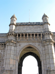
Gateway of India, Bombay (Mumbai).
The Gateway of India was designed in the Indo-saracenic style and was built to commemorate the visit of King George V and Queen Mary to Bombay on their way to the Durbar in Delhi in 1911.
The last British troops to leave India passed through the Gateway of India on 28 February 1948.
PHYSICAL ASPECTS.—The Bombay Presidency consists of a long strip of land along the Indian Ocean from the south of the Panjáb to the north Mysor, form 25º to 14º 3' N. lat. The coast is rock-bound and difficult of access; and thought it contains several bays forming fair-weather ports for vessels engaged in the coasting trade, Bombay, Karáchí, in Sindh, and Kárwár alone have harbours sufficiently land locked to protect shipping during the prevalence of the south-west monsoon. The coast-line is regular and little broken, save by the Gulfs of Kambay and Kachh, between which lies the peninsula of Káthiáwár.
Mountains.—Speaking generally, a range of hills, known as the Western Gháts (ghauts), runs down the coast, at places rising in splendid bluffs and precipices from the water's edge, at others retreating inland, and leaving a flat fertile strip of 5 to 50 miles between base and the sea. In the north of the Presidency on the right bank of the Indus, the Hálá mountains, a continuation of the great Sulaimán range, separate British India from the dominions of the Khán of Khelát. Leaving Sindh, and passing by the ridges of low sand hills,-- the leading feature of the desert east of the Indus,-- and the isolated hills of Kachh and Káthiáwar, which form geologically the western extremity of the Aravali range, the first extensive mountain range is that separting Gujarát from the states of Central India. The rugged and mountainous country south of the Taptí forms the northern extremity of the Sáhyádri or Western Gháts. This range of hills, sometimes overhanging the ocean, and generally parallel to it at distance nowhere exceeding 50 miles, with an average elevation of about 1800 feet, contains individual peaks rising to more than double that height. They stretch southwards for upwards of 500 miles, with a breadth of 10 to 20 miles. The western declivity is abrupt, the land at the base of the hills being but slightly raised above the level the sea. As is usually the case with the trap formation, they descend to the plains in terraces with abrupt fronts, The landward slope is in many places very gentle. the crest of the range being sometimes but slightly raised above the level of plateau of the Dakhín. Their best-known elevation is Mahábaleshwar, 4800 feet high, a fine plateau, 37 miles from Púna, covered with rich vegetation, and used by the Bombay Government as its summer retreat and sanitarium. In the neighbourhood of the Sáhyádri hills, particularly towards the northern extremity of the range, the country is rugged and broken, containing isolated peaks, masses of rock, and spurs, which, running eastward, form watersheds for the great rivers of the Dakhín. The Sátpurá hills separate the valley of the Taptí from the valley of the Narbadá, and the district of Khándesh from the territories of Indor. The Sátmálá or Ajantá hills, which are rather the northern slope of the plateaus than a district range of hills, separte Khándesh from the Nizám’s dominions.
Plains. –The more level parts of Bombay consist of five well-demarcated tracts—Sindh, Gujarát, the Konkan, the Dakhín or Deccan, and the Karnatic. Sindh, or the lower valley of the Indus, is very flat, with but scanty vegetations, and depending for productiveness entirely on irrigation. Gujarát, except on it northern parts, consists of rich, highly cultivated alluvial plains, watered by the Táptí and Narbadá, but not much subject to inundation. The Konkan lies between the Western Gháts and the sea. It is a rugged and difficult country, interested by creeks, and abounding in isolated peaks and detached ranges of hills. The plains of the Dakhín and Khándesh are watered by large rivers, but as the generally, during the greater part of the year, bleak and devoid of vegetation. The Karnatic plain, or the country south of the River Krishná, consists of extensive tracts of black or cotton soil in a high state of cultivation.
Rivers.—The chief rivers of Western India is the Indus, which enters the Presidency from the north of Sindh, and flowing south in a tortuous course, falls into the Arabian Sea by several mouths, such as the Ghizrí creek, Khudí creek, Pitiání creek, Sisá creek, Hajámrí creek, Vatho creek, Mall creek, Wárí creek, Bhitiárá creek, Sir creek, and Khorí creek. In the dry season the bed varies at different places from 480 to 1600 yards. The flood season begins in March and continues till September, the average depth of the river rising from 9 to 24 feet, and the velocity of the current increasing from 3 to 7 miles an hour. Next to the Indus comes the Narbadá. Rising in the Central Provinces, and traversing the dominions of Holkar, the Narbadá enters the Presidency at the north-western extremity of the Khándesh district, flows eastward, and after a course of 700 miles from its source, falls its source, falls into the Gulf of Kambay, forming near its mouth the alluvial plain of Broach, one of the richest districts of Bombay. For about 100 miles from the sea Narbadá is at all seasons navigable by small boats, and during the rains by vessels of from 30 to 50 tons burden. The Táptí enters the Presidency a few miles south of the town of Burhanpur, a station on the Great Indian Peninsula Railway, flows eastward through the district of Khándesh, the native state of Rewákánta, and the district of Surat, and falls into the Gulf of Kambay, a few miles west of the town of Surat. The Táptí enters the Presidency a few miles of the town of Burhanpur, a station on the Great Indian Peninsula Railway, flows eastward through the district of Khándesh, the native state of Rewákánta, and the district of Surat, and falls into the Gulf of Kambay, a few miles west of the town of Surat. The Táptí drains about 250 miles of country, and is, in a commercial point of view, the most useful of the Gujarát rivers. Besides these are many minor streams. The Banás and the Saraswatí take their rise in Aravali hills, and flowing eastward through the native state of Páhlanpur, fall into the Rann Kachh. The Sabarmatí and the Máhi rise in the Máhikánta hills, and flowing southwards, drain the districts of Northern Gujarát, and fall into the sea near the head of the Gulf of Kambay. The streams which, rising in the Sáhyádri range, or Western Ghátsm fkiw westward into the Arabian Sea, are of little importance. During the rains they are formidable torrents, but with the return of the fair weather they dwindle away, and during the hot seasons, with a few exceptions, they almost dry up. Clear and rapid as they descend the hills, on reaching the lowlands of the Konkan they become muddy and brackish and more regular flow than the streams of the Konkan. One of them, the Sheráwatí. Forcing its way through the western ridge of the Gháts, plunges from the high to the low country by a succession of falls, the principal of which is 8890 feet in height. The Sáhvádri, or Western Gháts, also throw off the eastward the two principal rivers of the Madras Presidency, the Godávarí and the Krishná. These rivers collect countless tributary streams, some of them of considerable size, and drain the entire plain of the Dakhín as they pass eastward towards the Bay of Bengal.
Lakes.—The Manchar Lake is situated on the right bank of the Indus. During inundations it attains a length of 20 miles, and breadth of 10, covering a total area estimated at 180 square miles. But the most peculiar lacustrine feature of the Presidency is the Rann or Lake of Kachh (Cutch), which, according to the season of the year, is a salt marsh, an inland lake, or an arm of the sea. Its area is estimated at 8000 square miles. It forms the western boundary of the province of Gujarát, and when flooded during the rains, unites the Gulfs of Kachh (Cutch) the Kambay, and converts the territory of Kachh into an island. In the dry season the soil is impregnated with salt, the surface in sine places being moist and muddy, and in others, like a dry river bed or sea-beach, strewn with gravel or shingle. The Rann is now used as the great source of salt supply for the whole Predency. Its present condition is probably the result of some natural convulsion. But whether the R_nn is an arm of the sea from which the waters have receded, or an inland lake whose seaward barrier has been swept away, still remains a matter of discussion.
Climate.—Great varieties of climate are met with in the Presidency. In its extreme dryness and heat, combined with the aridity of a sandy soil, Upper Sindh resembles the sultry deserts of Africa. The mean maximum temperature at Haidrábád, in Lower Sindh, during the six hottest months of the year, is 98º 5' in the shade, and the water of the Indus reaches blood heat; in Upper Sindh it is even hotter, and the thermometer has been known to register 130º in the shade. In Kachh and in Gujarát the heat, though less, is still very great. The Konkan is hot and moist, the fall of rain during the monsoon sometimes approaching 300 inches. The table-land of the Dakhín above the Gháts, on the contrary, has an agreeable climate except in the hot months, as has also the southern Marhattá country ; and in the hills of Mahábaleshwar, Singarh, and other detached heights, Europeans may go out at all hours with impunity. Bombay Island itself, though in general colled by the sea breeze, is oppressively hot during May and October. The south-west monsoon generally sets in about the first week in June, and pours down volumes of rain along the coast. From June to October travelling is difficult and unpleasant, except in Sindh, where the monsoon rains exert little influence.
Forest.—Bombay Presidency possesses two great classes of forest—those of the hills and those of the alluvial plains. The hill forests are scattered over a wide area, extending from 23º to 14º N. lat. Most of them lie among the Sáhyádri hills or Western Gháts The alluvial forests lie in Sindh, on or close to the banks of the Indus, and extend over an area of 550 square miles. The principal timber trees in the forests are—teak; blackwood of two varieties (Dalbergia Sisu and Dalbergia latifolia), Dalbergia ujainensis, Pterocarpus Marsupium, Terminalia Arabica, Acacia Catechu, Nauclea cordifolia, Nauclea parvifolia, Bidelia spinosa, Hardwikia binata, Juga xylocarpa, Populus euphratica, and Tamarix indica. The forests contain many trees which, on account of their fruits, nuts, or berries, are valuable, irrespective of the quality of their timber. Among these are the mango (Mangifera indica); the jack (Artocarpus integrifolia), Zizyphus Jujuba, AEgle Marmelos, Terminalia Chebula, Calophyllum Inophyllum, Bassia latifolia, and Pongamia glabra. The jungle tribes collect gum from several varieties of trees, and in Sindh the Forest Department derives a small revenue from lac. The palms of the Presidency consist of cocoa-nut, date palmyra, and areca catechu.
Geology.—Geologically the Bombay Presidency is divided into two tracts: the north-western part, consisting of Sindh, Kachh (Cutch), and Gujarát; and the southern-western, comprising the Marhattá country. Undulating sandy plains, with scattered craggy hills, are found in Gujarát ; the immense alluvial flats to the north being, for the most part, deserts of blown sand, and the fertile country consisting of a belt along the borders of the sea. In Sindh, the country, except on the banks of the Indus, or where reclaimed by irrigation, is an arid tract of gravel sand, from which rise steep scarps of limestone ranges. The rocks of Gujarát, Kachh, and Sindh, are only partially represented in the more southern peninsula, and are continuous with the formations found in Persia and Arabia. In the Marhattá country the greater portion of the surface is composed of nearly horizontal strata of basalt and similar rocks.
POPULATION.—The census of 1872 returns the total area of the Presidency, including Sindh, at 188,195 sqaure miles, and the total population at 25,624,696 souls. Details, however, are only available for the British part of the Presidency, which contains an area of 124,943 square miles, and a total population of 16,352,623 souls. The average density of population in the British districts is 131 persons per square mile, but it varies from a maximum of 29,291·13 in Bombay city to 14·20 in Thar and Párkar. Total number in the British districts, 2,164,338; and average number of persons per house, 4·99. Of the total population of the British portion, 12,440,659, or 76·08 per cent., are Hindus; 2,847,756, or 17·4 per cent., Muhammadans ; 192,245, or 1·17 per cent., Buddhists; 106,133, or 0·41 per cent, Pársís ; 603,836, or 3·69 per cent., aborigines; and 94,879, or 0·58 per cent., unspecified religion or nationality. The males number 8,547,100, or 52 per cent. of the population; the females, 7,805,523, or 48 per cent. The percentage of the total number of children under twelve years of age is 31·65. The Hindus are most numerous in Satára, and fewest in the Upper Sindh Frontier district. The Muhammadans form nearly the whole population of Sindh, and the least numerous in the Pánch Mahals. Except in Sindh, the Buddhist are widely scattered throughout the whole Presidency. The Christians are chiefly confined to Bombay city, Tánná, the Indo-Portuguese possessions, and the larger cantonments, such as Púna. The British districts of the Presidency contains upwards of 26,800 villages, and 175 towns of upwards of 5000 inhabitants. Besides Bombay city, there are 213 municipalities established under Act 26 of 1850. Of these, 4 have an income of over £10,000; 27 of over £1000; 22 of over £500; 94 of over £100; and 66 of under £100. Exclusive of the town of Bombay, the total municipal revenue realized in 1872-73 amounted to £198,857. Average rate of municipal taxation, 2s. 1 1/2 d. per head of the town population. The principal sources of municipal revenue are the octroi duties, house tax, and wheel tax.
AGRICULTURAL PRODUCTS.— The staple crops are as follows ; -- Joár (Sorghum vulgare) and bájrá (Holcus spicatus) are the staple food grains in the Dakhain and Khándesh. Rice is the chief product of Konkan. Wheat, generally grown in the northern part of the northern part of the Presidency, but specially in Sindh and Gujarát, is exported to Europe in large quantities from karáchí, and on a smaller scale from Bombay. Barley is principally grown in the northern parts of the Presidency. Náchní (Eleusine coracana) and Kidrá (Paspalum scrobiculatum), inferior grains grown on the hill sides, furnish food to the Kulís, Bhils, Wáralis, and other aboriginal tribes. Of the pulses the most important are gram (Cicer arietinum), túr (Cajanus indicus), kultí (Dolichos biflorus), and mug (Phaseolus Mungo). Principal oil-seeds: til (Sesamum orientale), mustard, castor-oil, safflower, and linseed. Of fibres the most important are cotton, Dakhíní hemp (Hibiscus cannabinus), and san or tág (Crotolaria juncea). Much has been done of late years to improve the cotton of the Presidency. American varieties have been introduced with much advantage in the Dhárwár collectorate and other parts of the southern Marhattá country. In Khándesh the indigenous plant from which one of the lowest classes of cotton in the Bombay market takes its name, has been almost entirely superseded by the super Hinganghát variety. Miscellaneous crops : -- Sugar-cane requiring a rich soil and a perennial water supply, and only grown in favoured, localities, red pepper, potatoes, turmeric, and tobacco. In 1871-72, 3,379,937 acres were under cotton cultivation; in 1872-73 the area increased to 3,715,945 acres. The total out-turn was 260,444 candies (560 lb) in 1872-73, against 221,144 in 1871-72. A legislative enactment has been passed to prevent adulteration of cotton, and in 1872-73, 24 persons, were convicted under it. In 1872-73, 2281 steam cotton gins were at work with 158 steam presses. Two model farms have been established in the Presidency—one at Hálá, near Haidarábád, in Sindh, and the other in Khándesh. Experiments have been instituted in the cultivation of fibres and tobacco. Large quantities of Carolina rice seed were distributed over the country, but the results hitherto cannot be deemed to have been successful. The same may be said of the endeavours which have been made to propagate the cinchona tree near Mahábaleshwar. Acreage under principal crops—Joár, 6552,385 acres; bajrá, 4,560,271; rice, 2,009,115; wheat, 1,322,835; and pulses, 1,167,809 acres. The land system of the Presidency is complicated, each province having a variety of tenures of its own. But the most important, and by far the most universal, is the survey tenure created by the British administration, which gives a right of occupancy to the holder on condition of his paying the Government demand.
PUBLIC WORKS AND RAILWAYS.—In 1872-73 the sum of £1,180,000 was expected on account of Public. Works in the Bombay Presidency; and the allotment under this head tends annually to increase. In the same year there were five railways open—1. The Great Indian Peninsula Railway: total miles open, 1278; total capital invested, £25,568; total receipt during the year, £1,872,826; working expenses, £1,203,200; net profit, £669,626. 2. The Bombay, Baroda, and Central India Railway: miles open, 389; capital invested, £8,418,202; receipts, £564,931; working expenses, £338,786; net profit, £226,145, 3.The Khámgáon State Railway : miles open, 8; capital invested £48,530; receipts, £1241; working expenses, £562; net profit, £679. 4. The Amráotí Railway: miles open, 5_; capital invested, £43m730; receipts, £2302; working expenses, £1241; net profit, £1061. 5. The Sindh section of the Sindh Panjáb and Dehli Railway: miles open, 106; capital invested £2,646,106; receipts, £157,1000; working expenses £118,934; net profit, £38,166. Total miles open of the above five railways, 1786_; total capital invested , £36,726,136; total receipts in 1872, £2,598,400; total working expenses, £1,662,723; total net profit, £980,667. Besides these, the following railways are either in progress or about to be undertaken : -- (1), State line, Southern Marhattá country; (2), Native State line, Viráwal, Junágarh, and Dhorájí; (3), Pátrí Branch (State line, light rail); (4), Anand and Dákor Brach; (5), Migángáon and Dhaboi Railway; (6), Wardhá to Hinganghát and Warorá : (7), Wadi to Haidarábád; (8), Khandwá to Indor. In 1872-73 the Bombay Telegraph Department had 4406 miles of wire in operation.
POST-OFFICES.—1872-73, 447 post-offices were distributed over the Presidency; total mileage of postal lines, 10,208 miles; total number of letters, parcels, &c., dispatched and received, 17,601,982.
MINES AND QUARRIES.—The Presidency of Bombay though dificent in mineral wealth, is abundantly supplied with stores of stone fitted for building and road –making purposes. At Teager, in the Dhárwár district, iron-ore is mined and smelted, but the scarcity of fuel prevent operations being conducted on an extensive scale. There are also large slate quarries in Dhárwár. Mándargé hill is quarried extensively for stone, the right of working it being annually sold by public auction. In Belgám district are quarries, from which building stones, stone bricks, or oblong quadrangular blocks of oft rock are obtained in abundance. Limestone is also found in the river beds of this district. There are a few trap and laterite quarries in the Ratnágiri district. The trap stone is used fro tank and well building, and for the plinths of houses; the laterite is used for house building. Near Karáchi are five quarries containing a species of limestone, largerly used in building in that town.
MANUFACTURES.—The indigenous manufactures of the country have rapidly declined since the influx of Manshester goods.But cotton weaving is still carried on upon a small scale in every village of any importance. Dyeing is practised in most places where fresh water is procurable. Printed cotton good are manufactured in all the large towns of Gujarát, and the further the locality is removed from the direct influence of railways the better the work is. This is owing to the competition of European cotton goods, which are sold much cheaper, and are more brilliant in colour, although less strong and durable, that the native manufactures. Most of the lower classes still wear home spun and woven goods; but the cotton-mills erected in Bombay, Broach, an in other parts of the Presidency, have introduced threads and cloths, which are readily bought up, an upon which the native workmen display their taste and skill. The cloths manufactured for the Marhattá castes are various kinds, Some are all cotton, or cotton and silk, some cotton silk with metallic threads, some silk with gold or silver thread. Admadábád, Yeolá, Ahmadnagar, Máligáon. Násik. Púná, and Dháwár , are all celebrated for their cotton goods. Carpets, rugs, horse cloths, towels, napkins, &c., made of cotto, are manufactured reputation for the strength and durability of its carpets; Khándesh and Dhárwár for druggets, rugs, and bullock cloths. A new future has lately been opened to manufacturing energy by the introduction of machinery from England. The ancient product of the Presidency, above named, are chiefly household industries. But large steam mills are now rapidly springing up in Bombay city, Broach, Surat, and other stations on the railway lines, especially in the cotton districts. Several of these employ over 1500 hands; one is reported to have nearly double that number; and the low rates of wage, with the natureal aptitude of the native for textile work, enables the Bombay mill-owners to complete with the Laneashire manufacturers, notwithstanding the heavy cost of importing manchinery and of European supervision. Several of the mills have a capital of some hundreds of thousands sterling invested in them; and their superior reputation for turning out unglazed and genuine goods has almost driven the lower qualities of Manchester fabrics from the market. In 1873 fifteen mills were at work in the town and island of Bombay, and five in other parts of the Presidency. Most of them have both spindles and looms, and their yarn and piece goods find a ready market. In Ahmadábád, Surat, Yeolá, Násik, and Bombay, considerable quantities of silk good are made, the silk being imported from China either in the cocoon or in skeins. Gold and silver thread enter largely into the manufacture of silk and cotton fabrics. The kinkháb (kincob), the richest kind produced, is either gold thread and silk, or silver, gold and silk. Embroidery in silk cloth and cotton, and in gold, silver, and silk thread, is carried on to some extent in Haidarábad, in Sindh, principally for European markets. Fibres are used for the manufacture of paper in Ahmadábád, Baroda, Surat, Násik, Bombay, and Kolhápur. Mats, beds, &c., are manufactured from cocoa-nut fibre. Leather is worked into a variety of articles throughout the Presidency. The manufactures of minor importance consist of pottery, brass, and copper untensil, cutlery, and agricultural implements, gold and silver ornaments, carved wood, ivory, &.c.
TRADE.—The total value of the external trade of the Presidency for 1872-73 was as follows: -- Bombay Port –imports, £17,388,953; exports, £19,117,081; re-exports, £5,140,924; total, £41,646,958. Minor ports—imports, £395,238; exports, £729,028; re-exports, £13,368; total, £1,137,634. Sindh ports—imports, £1,677,399; exports, £1,991,556; total, £3,668,955. Aden—imports, £1,407,102; exports, £834,087; total, £2,241,189. Total of the Presidency—imports, £20,868,692; exports, £22,671,752; re-exports, £5,154,292; total, £48,694,736. In the same year 5314 ships, having a tonnage of 902,157 tons, cleared from Bombay harbour,and 5208 ships, of 161,907 tons, from the minor ports. Principal articles of commerce—cotton, cotton piece-goods, wool and woolen piece goods, machines and machinery, oils, tea, wines and spirits, metals, coal, candles, jute and gunny cloths, apparel, sugar and sugar-candy, twist, hides and skins, grains and pulse, bullion, &.c. In 1872-73 upwards of 55,300 tons of cotton were imported into Bombay in the shape of Manchester goods, and 143,017 tons of raw cotton exported from it.
REVENUE AND EXPENDITURE.—The total revenue of the Presidency for the year 1872-73 amounted to £9,980,043, and the expenditure to £8,027,040. The principal heads of revenue are as follow: -- Land, £3,751,050; tributes and contributions from native states, £92,337; forests, £114,640, excise, £418,746; assessed taxes, £110,098; customs, £667,825; salt, £885,013; opium, £2,614,897; stamps, £527,382; law and justice, £29,677; marine, £64,475; interest, £103,209. The settlement of the land revenue is usually made for thirty years. A revision of the thirty years’ settlement of Poona, Násik, and Sholápur districts, is now (1874) in progress.
STATISTICS OF PROTECTION.—The military strength of the Bombay Presidency consists of 1250 European commissioned officers, 11,067 European non-commissioned officers and rank and file, 27,002 Native commissioned and non-commmissioned officers and rank and file; total 39,319. The whole are under the control of a separate commander in-chief for Bombay. Ten ships constitute the strength of the Bombay marine. The regular police of Bombay consisted in 1872-73 of 18,166 officers and men, maintained at a total cost of £305,810; the average being 1 man to every 6·8 square miles of the area, and to 900 of the population.
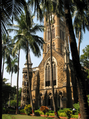
University of Bombay.
A wonderful example of the Gothic revival style, these buildings were built in the late 19th century and feature a 260 feet high clock tower.
EDUCATION.—The University of Bombay, established in 1857, is a body corporate , consisting of a chancellor, vice-chancellor, and fellows. The Governor of Bombay is ex-officio chancellor. The Education Department is under a director of public instruction,k who is responsible for the administration of the department in accordance with the general educational policy of the state. In 1872-73 the number of schools and colleges aided by the state or under its inspection was a follows; --7 colleges, attended by 544 pupils; 4 professional school, with 275 pupils; 41 high schools, 7167 pupils; 176 middle class schools, 16,612 pupils; 3595 lower class schools for boys 182,147 pupils; 253 lower class schools for girls, 10,885 pupils; 12 normal schools, 602 pupils; total 4088 schools, 218,466 pupils. The total cost for the schools was £285,650, of which the state contributed £99,600; the balance being obtained from school fees, local contributions, private endowments, &c.
HISTORY.—The territories now comprising the Presidency of Bombay formed in ancient times several separate Hindu Kingdoms, among which Maháráshthra, Gujaráshthra, Sindhu, were the most important. As in other parts of India, the great majority of the people are Hindus, with more recent accretions of Muhammadans, and a sprinkling of hill-tribes practicing non-Hindu rites, and representing the pre-Aryan races. The first Muhammadan invasion of which we have authentic accounts is that of Mahmúd of Ghazní, who, in 10024 A.D., invaded Gujarát with large army, destroyed the national Hindu idol of Somnáth, and carried away an immense booty. Muhammad Ghorí also invaded Gujarát, and left a garrison in its capital. But it was not till after the Musalmán power was firmly established in Northern India that the Muhammadan sovereigns of Dehli attempted the conquest of the south. In 1294 the Emperor Alá-ud-dín first invaded the Dakhín (Deccan), and in 1297 he conquered Gujarát. In 1312 the Muhammadan arms were triumphant through the Marhattá country ; and seven years later the whole of Malabar fell a prey to the invaders. In the middle of the 14th century the weakness of the Dehli sovereigns tempted the governors of provinces to revolt against their distant master, and to form independent kingdoms. In this way the Báhminí kingdom was established in the Dakhín, and embraced a part of the Bombay Presidency. Ahmadnagar and Gujarát also became the seats of a new kingdom. In 1573 Akbar conquered Gujarát and reannexed it to the empire, and in 1601 he effected the reconquest of Ahmadnagar and Khándesh. From this time the country was never tranquil, and Ahmadnagar be came the focus of constant rebellions. During the latter part of the 17th century the Marhattás rose into power, and almost every part of the country now comprising the Presidency of Bombay fell under their sway.
As early as 1532 A.D. the island of Bombay was occupied by the Portguesse. The Dutch and English made an unsuccessful attempt to gain possession of the island in 1627, and in 1653 proposals were suggested for its purchase from the Portuguese. In 1661 it was ceded to the English Crown, as part of the dower, of the Infanta Catherina on her marriage with Charles II. So lightly was the acquisition esteemed in England, and so unsuccessful was the administration of the Crown officers, that in 1668 Bombay was transferred to the East India Company for an annual payment of £10. The population at that time did not exceed 10,000 souls, and so unhealthy was the climate, that three years were regarded as the average duration of the life of its European inhabitants. At the time of the transfer, powers for its defence and for the administration of justice were also conferred; a European regiment was enrolled; and the fortification erected proved sufficient to deter the Dutch their intended attack in 1673. In 1687 Bombay was placed at the head of all the Company’s possessions in India; but in 1753 the Government of Bombay became subordinate to that of Calcutta. The first English settlement in the Bombay Presidency was in 1618, when the East India Company established a factory at Surat, protedted by a charter obtained from the Emperor Jahángir. After the termination of the second Marhattá war in 1803, the East India Company obtained the districts of Surat, Broach, Kairát. &c.; and on the overthrow of the Peshwá in 1813, they annexed Púná, Ahmadnagar, Násik, Sholápur, Belgám, Kálaogí, Dhárwár, &c. Sindh was conquered in 1843, and became a part of the British empire. The native states under the supervision of the Government of Bombay are divided, historically and geographically, into two main groups. The northern or Gujarát group includes the territories of the Gaikwár, with the smaller states which form the administrative divisions of Kachh, Páhlanpur, Rewá Kánta, and Máhi Kánta. These territories, with the exception of Kachh (Cutch), have an historical connection, as being the allies or tributaries of the Gaik wár in 1805, when final engagements were concluded between that prince and the British Government. The southern or Marhattá group, includes Kolhápur, Akalkot, Sáwantwárí, and the Sátárá and southern Marhattá Jágírs, and has an historical bond of union in the friendship they showed to the British in their final struggle with the power of the Peshwá in 1818. The remaining may conveniently be divided into a small cluster of independent zamíndáris, situated in the wild and the hilly tracts at the northern extremity of the Sáhyádri range, and certain principalities which, from their history of geographical position, are to some extent isolated from the rest of the Presidency.
ADMINISTRATION.—The Government of Bombay is administered by a Governor in Council, the latter consisting of the Governor as president, two ordinary civil members, and, as a rule, the commander-in –chief of the Bombay army. These are the executive members of Government. For making laws there is a legislative council, consisting of the Governor and his Executive Council, with certain other persons, not fewer that for or more than eight in number, nominated by the Governor to be members of council for legislative purposes only, and intended to represent the non-official European and Native communities. Each of the member of the Executive Council has in his charge one or two departments of the Government; an each department has a secretary, an under-secretary, and an assistant secretary, with a numerous staff of clerks. The political administration of the native states is under the superintendence of British agents placed at the principal native courts; their position varies in different states according to the relations in which the principalities stand with the paramount power. The administration of justice throughout the regulations districts of the Presidency is conducted by a High Court at Bombay, consisting of a Chief Justice and severn Puisne judges, along with district and assistant judges throughout the districts of the Presidency. The revenue administration of the regulations districts is carried on by two revenue commissioners, seventeen collectors, twenty assistant collectors, and a varying number of supernumerary assistants. (W. W. H.)
BOMBAY CITY AND ISLAND.
The Island of Bombay, with an area slightly in excess of 22 square miles, is situated in 18º 53´ 54' N. lat. ,and 72º 52' E. long. It consists of a plain about 11 miles long by 3 broad, flanked by two parallel lines of low hills. A neck of stretching towards the south-west forms the harbour on its eastern side, sheltering it from the force of the open sea, and enclosing an expanse of water from 5 to 7 miles wide. At the south-west of the island, Back Bay, a shallow basin rather more than 2 miles in breadth, runs inland for about 3 miles between the extreme points of the two ranges of hills. On a slightly raised strip of land between the head of Back Bay and the harbour is situated the fort, the nucleus of the city of Bombay. From this point the land slopes westward towards the central plain, a low lying tract, which before the construction of the embrankment known as the Hornby Velard, used at high tide to be submerged by the sea. To the north and east, although causeways and railway embankments have now shut out the sea, a large area of salt-marsh land still remains subject to inundation.
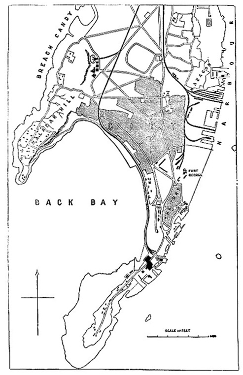
Ground Plan of Bombay
In the foregoing article on the Bombay Presidency it is explained that Bombay Island passed to the English Crown as part of the dower of the Infants Catherina, on her marriage with Charles II., and that although the new acquisition was at first despised, it rose in 1687 to the chief importance in the East India Company’s possessions. In the next century it declined before the growth of Calcutta, and sank into a subordinate settlement. The present century has again witnessed a revolution in its fortunes. Its splendid harbour and comparative nearness to the Suez Canal, with the system of railways which now connect Bombay with the other Presidencies, have marked out for it a career scarcely second, if at all second in commercial importance, to that of Calcutta itself. The suddent demand for Indian cotton, which resulted from the American war, gave an unprecedented rapidity to its development. The cotton o Gujarát, Dhárwár, and other parts of Bombay, is much superior to the Bengal fibre. Several years of brilliant prosperity culminated in 1866-67 in a financial crisis, Depending as it does chiefly on the article of cotton, along with some export of grains and the Government opium, the trade of Bombay rest on a narrower basis than that of Calcutta, which in years of misfortune has a large variety of staples to fall back upon, such as tea, indigo, jute, rice, hides, oil-seeds, &c. Moreover,, Bombay has only costly railway communication with the interior parts of India, while Calcutta commands the confluence of two of the greatest river system in the world, the Brahmaputra and the Ganges. Nevertheless, Bombay is pressing close upon Calcutta as the commercial capitall of India. Its imports are about ad great, and its export not very far short. In 1871-72 its total trade was £50,384,929 against a total of £54,136,829 in Calcutta. In that year the Bombay imports were 22 1/3 millions sterling; the exports, 23 1/3 millions, and the re-exports, 4 1/2 millions: total, 50 1/3 millions sterling.
In natural scenery and in the sanitary advantages of its position Bombay Island, or, as it ought to be more correctly called, the Bombay Peninsula, is now connected with the mainland by the railways causeways, It stands out from a coast ennobled by lofty mountains, and its harbour is studded by rocky islands and precipices, whose peaks rise to a great height. The approach from the sea discloses one of the finest panoramas in the world, -- the only European analogy being the Bay of Naples. The town itself consists of well-built and unusually handsome native bázárs and of spacious streets devoted to European commerce. In the native bazaar the houses rise three or four stories in height, with elaborately carved pillars and front work. Some of the European hotels and commercial front work. Some of the European hotels and commercial buildings are on the American scale, and have no rival in any other city of India. The private housed of the European residents lie apart alike from the native and from the mercantile quarters of the town. As a rule, each is built in a large garden or compound; and although the style of architecture is less imposing than that of the stately residences in Calcutta it is well suited to the climate, and has a beauty and comfort of its own. The favourite suburb is Malabar hill, a high running out into the sea, and terraced to the top by handsome houses, which command one of the finest views in the world. To the right of this ridge, looking towards the sea, runs, another suburb known as Breach Candy, built close upon the beach and within the refreshing sound of the waves. To the left, of Malabar hill the island forms a spacious bay, with a promontory at the other side, which marks the site of the old Bombay Fort. The fort is now a mere garrison, with small pretensions to defensive capabilities. It walls are demolished, and its area is chiefly devoted to mercantile buildings. Further round the island, beyond the fort, is Mazagon Bay, commanding the harbour, and the centre of maritime activity. The defences of the port consist chiefly in ironclad "Monitors" anchored off the town, with one or two fortified islands, and the guns which still line a portion of the old fort walls that have been left standing toward the sea. The census of 1872 disclosed a population of 644,405 souls; of whom 408,680, or 63·42 per cent., are Hindus; 138,815, or 21·54 per cent., Muhammadans; 44,091, or 6·84 per cent., Pársís; 15,121, Buddhists and Jains: 34,705, or 5·39 per cent., European, African, Eurasian, and Native Christians, with 2993 classified under the head of "others."Dyeing, tanning, and working in metals may be notice as specially active trades, but the most progressive and important industry is the manufacture of yarn and cotton cloth. In 1873 there were 5 steam spinning and weaving mills in Bombay, giving employment to about 11,000 hands. In these factories 380,000 spindles and 5000 looms were at work. A considerable section of the population is supported by the cultivation of cocoa-nut trees and the preparation of intoxicating drinks from the juice of the different species of palm. Rice is the chief agricultural product, but many varieties of garden vegetables are profitably cultivated. Of these the most common are onions, "bhendis" (Abelmoschus esculentus), and gourds of different sorts. The imperial revenue from the town and island of Bomabay is derived from two sources, -- the one supervised by the collector of Bombay, the other by the commissioner of customs. The total receipts for the past year, under the first head, amounted to £23,131 was derived from land, £17,250 from excise, and £107,906 from stamps. The total amount collected by the commissioner of customs was £3,252,714, of which the customs yielded £609,630, and the export duty on opium £2,643,084. Owing to the difficulty of procuring colonists in the early days of the settlement, the land is generally held on easy terms,-- the payment to Government being in most cases of the nature of a quit rent, free from enchancement or resettlement as long as the land is used for cultivation only. Of the whole area, 13 miles are returned as cultivated, and 9 as unculturable. During the year 1872 there were 101 schools in Bombay, attended by 11,351 scholatrs, or 1 to every 56 of the entire population. The total strength of the local police force in 1872 was 1402, or 1 policeman to every 459 inhabitants. OF the entire number, 1124 are municipal, and 278 Government police. Of the former, 35 are European, and 13 are mounted Native police. The Government police employed on harbour duty and as guards for Government offices. Eight of them are Europeans.
MUNICIPAL STATISTICS.—The limits of the Bombay municipality extend over the whole of the island of Bombay, including, as stated above, a population of 644,405 souls. The total municipal revenue for the year 1873 amounted to £314,645, of which £223,041 was raised by taxation, £59,958 on account of services rendered, and £31,646 from municipal property and miscellaneous receipts. The following are the main items under the head of taxation proper: -- House rate, £73,587; police rate, £24,189; lighting rate, £21,179; wheel taxes, £23,197; tobacco and liquor duty and licenses, £28,690; town duties £45,200; and additional rate from Port Trust, £4000. Under the head, Service rendered, are included the Halálkar cess and the water rate, yielding respectively £20,392 and £39,566. The returns under the third head are chiefly receipts from the Crawford markets. The total expenditure was £312,208. OF this amount £25,325 was spent on general supervise on, £36,041 in supporting the police and fire brigade. Under the head of public health, £87, 575 was spent, and £84,835 on public works. The interest and sinking fund on the police debt consumed £74,496. The incidence of municipal taxation per head of the population is 6s. 9d. It is estimated that the gross annual income of the city is about 855 lakhs of rupees, or upwards of 8_ millions sterling, on which sum the municipal taxation proper amounts to about 2·57 per cent., and the total municipal income and expenditure to about 3·64 per cent. The municipal debt at present to about £790,000 or nearly 2 1/2 years’ income. (W. W. H.)
The above article was written by Sir William Wilson Hunter, M.A., LL.D. C.I.E, K.C.S.I.; Director-General of Statistics to the Government of India, 1871; edited the Imperial Gazeteer of India; author of A Brief Account of the Indian Peoples, A Statistical Account of Bengal and Assam, and Life of the Marquis of Dalhousie.
|