1902 Encyclopedia > Kashmir
Kashmir
KASHMIR, or CASHMERE, an elevated and enclosed valley in the Himalaya mountains, north of the Punjab. It is surrounded by lofty hills, with one opening on the west, by which flows out from the valley the river Jhelum. The enclosing hills on the north and east belong to the Bara Lacha chain, and on their outer side is the broad mountainous region which holds the valley of the upper Indus, and which, beyond the Indus, culminates in the great parallel range of Karakorum or Mustagh. On the west and south, the hill boundary, which joins the other half of the enclosure at the south, the hill boundary, which joins the other half of the enclosure at the south-east end of the valley, is the Paujal or Panchal range, which on its outer side sends down its branches southward, through the Jamu territory, to the plains of the Punjab. The length of the Kashmir valley, including the inner slopes of its surrounding hills, is about 120 miles from north-west to south-east. Its greatest width is about 75 miles. The low and comparatively level floor of the basin is 84 miles long and 20 to 24 miles broad. Its lowest part is 5200 feet above the sea, and its mean height 6000 feet.
This valley is but a small portion, in area, of the dominions of the maharaja of Kasmir, which, in addition of the maharaja of Kashmir, which, in addition to the Jamu territory on the south (the previous possession of the present maharaja’s father, Ghulab Singh, before he acquired Kashmir), include Baltistan and Gilgit on the north, and Kishtwar and Ladak on the east. On the west Kashmir is separated from the valley of Khagan by a continuous range of high hills, and from the British district of Hazara by the river Jhelum.
Jamu, to which Kashmir was annexed in 1846, occupies the southern slopes of the Panjal range, with a strip of plain country at their foot and extends about 220 miles from east to west, with a greatest direct breadth, north to south, of about 75 miles. All the rest of the maharaja’s dominions is hill country.
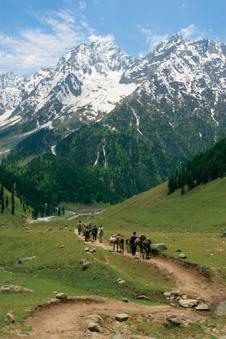
Himalaya Mountains in Kashmir, India
The hills forming the northern half-circuit of the Kashmir valley, and running beyond, include many lofty mountain masses and peaks, the most conspicuous of which, a little outside the confines of Kashmir, is Nanga parbat, a grand hill (35° 15’ N., 74° 35’ E.), rising 26,629 feet above the sea, with an extensive area of glacier on its eastern face. The great ridge which is thrown off to the south-west by Nanga parbat rises, at a distance of 12 miles to another summit 20,740 feet in height, from which run south-west and south-east the ridges which are the northern watershed boundary of Kashmir. The former range, after running 70 miles south-west, between the valleys of the Kishanganga and the Kunhar or Nain-sukh, turns southward, closely pressing the river Jelum, after it has received the Kishanganga, with a break a few miles further south which admits the Kunhar. This range presents several prominent summits, the two highest 16,487 and 15,544 feet above the sea. The range which runs south-east from the junction peak above-mentioned divides the valley of the Kishanganga from that of the Astor and other tributaries of the Indus. The highest points on this range, where it skirts Kashmir, are 16,795, 16,930, and 17,202 feet above the sea. For a distance of more than 50 miles from Nanga Parbat there are no glaciers on this range; thence eastward they increase; one, near the Zoji-la-Pass, is only 10,850 feet above the sea. The mountains at the east end of the valley, running nearly north and south, drain inwards to the Jhelum, and on the other side of the Wardwan, a tributary of the Chenab. The highest part of this eastern boundary is 14,700 feet. There are no glaciers. The highest point on the Panjal range, which forms the south and south-west boundary, is 15,523 feet above the sea.
The river Jhelum or Behat (Sanskrit Vitasta) – the Hydaspes of Greek historians and geographers – flows north-westward through the middle of the valley. After a slow and winding course it expands, about 15 miles below Srinagar, over a slight depression in the plain, and forms the Wular lake and marsh, which is of ill-defined extent, but may be called about 10 miles long and 6 broad. The hills which this lake touches at its north end give it a more defined margin on that side. Leaving the lake on the south-west side, near the town of Sopur, the river pursued its sluggish course south-westward, about 18 miles, to the gorge at Baramula. Form this point the stream is more rapid through the narrow valley which conducts it westward 75 miles toMuzaffarabad, where it turns sharply south, joined by the Kishanganga. At Islamabad, about 40 miles above Srinagar, the river is 5400 feet above sea-level, and at Srinagar 5235 feet. It has thus a fall of about 4 feet per mile in this part of its course. For the next 24 miles to the Wular lake, and thence to Baramula, its fall is only about 2 _ feet in the mile. On the 80 miles of the river in the flat valley between Islamabad and Baramula there is much boat traffic; but none below Baramula, tillthe river comes out into the plains.
On the north-east side of this low narrow plain of the Jhelum is a broad hilly tract between which and the higher boundary range runs the Kishanganga river. Near the east end of this interior hilly tract, and connected with the higher range, is one summit 17,839 feet. Around this peak and between the ridges which run from it are many small glaciers. These heights look down on one side into the beautiful valley of the Sind river, and on another into the valley of the Lidar, which join the Jhelum. Among the hills north of Srinagar rises one conspicuous mountain mass, 16,903 feet in height, from which on its north side descent tributaries of the Kishanganga, and on the south the Wangat river, which flows into the Sind. By these rivers and their numerous affluents the whole valley of Kashmir is watered abundantly.
Around the foot of many spurs of the hills which run down on the Kashmir plain are pieces of low table-land, which are called karewa. These terraces vary in height at different parts of the valley from 100 to 300 feet above the alluvial plain. Those which are near each other are mostly about the same level, and separated by deep ravines.
The level plain the middle of the Kashmir valley is fine clay and sand, with water-worn pebbles. The karewas consist of horizontal beds of clay and sand, the lacustrine nature of which is shown by the shells which they contain. The hills surrounding the valley are chiefly gneiss and schists. In the Lidar valley are slate and sandstones of the Carboniferous period over green slate of a period corresponding to Silurian. The irregular ridges of the Panjal range are granite and gneiss, with schists and slates. Limestone is found in parts of the east and west ends of the valley, and in the hills upon the Manas bal lake. In various places are marks of glacial action, down to a height of about 500 feet above the level part of the basin. From the plain rise isolated hills of trap; among these are the hari Parbat and the Takht-I Suliman at Srinagar, on the former of which stands the fort, and on the latter a conspicuous and well known ancient Hindu temple. No fossils have been found in Kashmir below the rocks of the Carbonuiferous period. The chief mineral resources of the maharaja’s dominions are outside the Kashmir valley, specially in Ladak.
In the hills of the north boundary are two passes, the Burzil (13,500 feet) and the Kamri (13,200). By the former is the direct route between Srinagar and Iskardo it is usually practicable only between 15th July and 15th September. The road from Srinagar to Le In Ladak goes by the Zoji-la Pass (11,300 feet), near the north-east corner of the valley. Only a short piece of the road, where snow accumulates, prevents this pass being used all the year. At the south-east end of the valley are three passes, the Murgil (11,600 feet), the Hoksar (13,315), and the Murbul (11,550) all leading over to the valleys of the Chenab and the Ravi. South of Islamabad, on the direct route to Jamu and Siakot, is the Banihal Pass (9200 feet). Further west on the Panjal range is the Pir Panjal or Panchal Pass (11,400 feet), with a second pass, the Rattan Pir (8200 feet), across a second ridge about 15 miles south west of the other. Between the two passes is the beautifully situated fort of Baramgali and a well-known rest-house for travelers. This place is in the domain of Raja Moti Singh of Punch, cousin and tributary of the maharaja of Kashmir. At Rajaori, south of these passes, the road divides: one line leads to Bhimbar and Gujrat, the other to Jamu and Sialkot by Aknur. Next, south-west of Baramula, is the Hajji Pir Pass (8500 feet), by which crosses the road to Punch. From Punch one road leads down to the plains at the town of Jhelum, another eastward through the hills to the rattan Pir Pass and Rajaori. Lastly there is the river pass of the Jhelum, which is the easy route from the valley westward, having two ways down to the plains, one by Muzaffarabad and the Hazara valley to Hassan Abdal, the other by the British hill station of Marri (Murree) to Rawal Pindi.
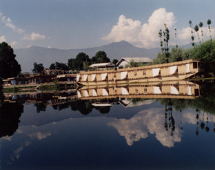
Houseboat, Srinagar, Kashmir, India
The valley of Kashmir, sheltered from the south-west monsoon by the panjal range, has not the periodical rains of India. Its rainfall is irregular, greatest in the spring months. Occasional heavy storms in the monsoon pass over the crests of the Panjal and give heavy rain on the elevated plateaus on the Kashmir side. And again clouds pass over the valley and are arrested by the higher hills on the northeast side, on which they pour themselves. Snow falls on the surrounding hills at intervals from October to March, and sometimes in great quantity. In the valley the first snow generally falls about the end of December, and never to any great amount. The highest monthly average of temperature form May to October, at Srinagar, is 89° in the shade at noon. There has been no regular winter register; but the temperature is never very low.
For all crops except rice, which is irrigated, the rain is ordinarily sufficient. Barley, sown in November, ripens in June, wheat in July. Rice, sown in May and June, ripens in October. Millet, maize, and buckwheat, also turnips, pease, and mustard, are grown in considerable quantity.
There is no natural forest in the level parts of the valley. Of the cultivated trees the finest is the plane (chinar), which grows to a large size, and is of great beauty. The principal other trees of the valley are the poplar, willow, cypress, walnut, apple, pear, quince, apricot, cherry, mulberry. Vine are grown extensively, commonly trained up poplar trees. There are many kinds of grape. On the hills around are deadar, Pinus excelsa and Gerardiana, Picea Webbiana, hazel, birch, viburnum, juniper, rose &c. The herbaceous plants and flowers are very numerous. The umbelliferous plant called prangos, growing on the drier hills, is much valued as winter food for sheep. In spring the bright orange-colored colchicum shows itself in great quantity; and in autumn are seen many acres of saffron with its beautiful light purple flowers, grown in large fields divided into small square beds. Saffron was among he articles of annual tribute to the Mughal emperors. The Dal lake at Srinagar is full of reeds and water plants, Potamogeton, Nymphaea, Nelumbium, &c. On this lake there are floating gardens: a shallow layer of soil on sheets of the great leaves of water lilies is made to grow quantities of vegetables. The curious singhara, or horned water nut (Trapa bispinosa), which grows in great quantity in all the lakes, is much used for food, prepared in various ways. Since 1874 hops have been grown experimentally for the Murree Brewery Company, with fair success, in five different parts of the valley.
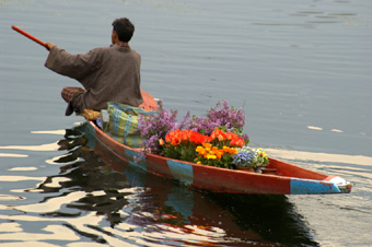
Flowerseller on boat, Srinagar, Kashmir
Much has been said and written about the beauty of the vale of Kashmir. Spring encircles a fresh, green, smiling valley with a noble belt of glistening snow-capped ridges; autumn fills the eye with the wonderful richness of the many-colored foliage. At all times flows on the quiet glassy river, showing back the groves and avenues upon its banks the strange tall shadowy wooden houses, and the craggy hills. There is no place or season which has not something to show of real beauty. The rapturous praises of Mohammedan writers may be often extravagant; and it is with some of their materials, reproduced with more modern additions, that Moore has built up great part of his romance; still few will really think that here extravagance and fiction have left truth much too far behind.
Many Englishmen every year resort to Kashmir for shooting. The game is in consequence now only to be found within reduced areas of the more secluded little valleys and more difficult hill sides, and many sportsmen now cross over into Ladak. The animals chiefly sought in both countries are the Ovis ammon, ovis poli, antelope, ibex mar-khor or wild goat, must deer, Tibetan stag, brown and black bear, and leopard. In various parts of Kashmir are to be found the fox, lynx, weasel, marmot, and hare. The black and grey monkey (langur) is common on the Panjal range. Kashmir has the snow pheasant, snow owl wild goose, duck, and teal; and the eagle is also found.
The Kashmir valley has a large number of old buildings of the Hindu period, interesting from their style, which is peculiar to Kashmir, and from the traces which many of them bear of Greek art. Their ruinous condition is ascribed partly to Sikandar te idol-breaker, partly to earthquakes, which are frequent in Kashmir. The most ancient of these buildings (about 220 B.C.) is the temple of Shankar Acharya (or, as it was formerly called, of Jaiasht Iswar), on the hill at Srinagar, known as Takh-I-Suliman, or Solomon’s Throne, - a designation thought to be a Mohammedan adaptation of the name of Raja Sandhaman, who repaired or rebuilt the temple. The other Hindu buildings mostly belong to the time from the 5th to the 10th century. The chief points which distinguish them from hindu buildings in India are the tefoil-headed doorways and recesses, high pediments, high straight-lined pyramidal roofs, and fluted pillars.
The temple of the sun at Marttand or Matan has been one of the finest. It occupies a very striking position on a karewa or natural terrace about 3 miles from Islamabad, and commands a splendid view of the valley of the Khelum. Of the others the most worthy of notice are the remains of two of the four temples at Avantipur, 15 miles south-east of Srinagar; the temple of Bhumzo near Marttand, built in a cave; Payach, on the karewa of Naunagar near Avantipur, a small temple, the whole superstructure built of six stones; Pandretan, 3 miles south-east of Srinagar, standing with its floor below the water, in a tank; Bhaniar (Bhawaniar) and Kutrui, a few miles west of Baramula, both backed by fine wooded cliffs crowned with deadars. A mound, with masonry in and about it, at the village of Ushkara near Baramula, is supposed to be the remains of a Buddhist tope (stupa), the place taking its name from Hushka, one of the Tartar kings of Kashmir.
Srinagar, the capital (34° 4’ 6" N., 74° 48’ 5" E.), said to have been founded by Pravara Sen, in the beginning of the 6th century, is built on both banks of the Jhelum. It is a somewhat confused mass of houses, many of them built of wood, with balconies and carved lattice windows, and projecting upper stories propped on poles, and overhanging the narrow streets or the little canals which is some parts are the streets. The city has seven bridges across the river, built of beams laid on stone and timber piers. In the fort on the south side of the river is the palace. There are several small Hindu temples in the town. The two chief mosques are the Jami mosque and that of Shah Hamadan, the latter one of the most conspicuous buildings, with walls of stone and timber, low sloping wooden roof, and little wooden spire. On the shores of the Dal lake are the old pleasure-gardens of the Mughals.
The people of Kashmir are now mostly Mohammedan. Physically of fine form, a large proportion of the town-people are enfeebled by poverty and sedentary occupation in close rooms. A few years ago the shawl weavers of Srinagar were reckoned to be about 22 per cent. of the inhabitants. The proportion is now less, owing to the reduced demand for Kashmir shawls, both loom-made and hand-sewn. The maharaja has endeavored to meet the depression of the shawl trade by extension of silk manufactures; silk is successful worked, and well dyed. The chief demand for shawls has generally been from France, and French patterns have somewhat interfered with native art. At Islamabad also many hands are employed in shawl and blanket weaving. A kind of coarse chintz is also made there. Embroidery on fine woolen cloths is the employment of many Kashmiris, both in their own country and in their Indian settlements, Amritsar, Nurpur, and Ludhiana. The manufacture of a variety of articles in papier mache and ornamentall painted wood-work employs a number of people in Srinagar. The silversmiths do as good deal of business in ornamental vases, goblets, flower-holders, &c., silver and silver gilt. Engraved and embossed copper work employs a smaller number of people; also the manufacture of ornamental vessels of tinned copper, and some other minor kinds of work. A very good kind of paper is made in Kashmir. A museum of Kashmir products and manufactures was established at Srinagar in 1875. the people of the country, with more healthful occupations and surroundings than those of the towns, especially Srinagar, are robust and of active habits. The kashmiris, both men and women, wear commonly a kind of loose gown with sleeves, pheran (Pers. Pairahan, "a robe"). In cold weather they are in the habit of carrying, under this loose dress, a small portable brazier with heated charcoal. The country people and boatmen use a more closr-fitting costume. The mountaineers, like those of neighboring hill countries, bandage the legs from the knee to the foot for protection in walking.
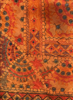
Kashmiri fabric
According to a report prepared by order of the maharaja in 1873, the population of the valley at that time was nearly 492,000. of these about 64,000 were Hindus and the rest Moslems, about 4 per cent, of the latter being Shiites. The estimated population of Jamu was 861,000, of Punch 77,5000, of Ladak, Iskardo, and Gilgit, 104,500; total about 1,535,000:-- Hindus, 507,000; Moslems, 919,000; Buddhists, 20,000; and "miscellaneous," 89,000. of Srinagar the estimated population was about 132,000, of which number nearly 40,000 were Hindus. A great diminution, caused by deaths and emigration, has followed the famine of 1878. it was said that the towns of Islamabad and Sopur lost nearly two-thirds of their inhabitants. The rice crop of 1879 was abundant, and the rains of the next year seasonable and plentiful. The shawl-weaving and carpet-making trades revived in 1880, and numbers of people who had left the country during the famine returned.
The language of Kashmir (which is spoken only in the valley itself, and in the few outlying settlements of Kashmiris in the neighboring hills and in northern India) is of the Aryan family. It is allied to the Hindi, Sindi, and Punjabi, and also to the current Urdu of India (Hindustani). It uses a form of the Sanskrit character like the Nagari of the Punjab. It may be said to possess no literature, though Kashmir has produced many literary men. The Urdu is now very generally understood in Kashmir, among he better educated people and more intelligent artisans.
The chief articles of export from Kashmir are shawls and other woolen fabrics, rice, saffron, fruits. The chief imports are shawl wool, English piece goods, Indian cloths, metals, precious stones, skins, felts, dye-stuffs, tea, charas (hemp juice), groceries, and salt. The imports into Kashmir from British India are much below those into Jamu, except tea (of which the Kashmiris are extremely fond), indigo, and earthenware. Kashmir imports annually a very large amount of rock salt from the Punjab. The gross annual value of the imports is about £210,000, and of the exports about £172,000. this latter amount is less than formerly, owing chiefly to the reduced demand for shawls. The import duties, which used to be very heavy, were modified in 1864; the duty of piece goods was limited to 8 per cent. and on other imports to 12 _ per cent. In April 1870 a commercial treaty was entered into with the British Government for developing trade with eastern Turkestan, in which, among other things, the maharaja agreed to abolish all transit duties. Joint commissioners were appointed, on the part of the two Governments, to reside at Leh.
The gross annual revenue of Kashmir is believed to be about £550,000, and of the maharaja’s whole territories a little over £800,000. the chief source of income is the land revenue. Of this there is now a cash settlement in place of the annual valuation of crops which was the practice till lately. The Government ordinarily takes one-half the gross produce. Grain is stored in public granaries, and sold at fixed rates to the army and the civil officials. Much grain is also purchased from the zamindars, and stored by Hindu merchants in Srinagar.
The maharaja’s military force numbers 25,600 infantry (including police), 1400 cavalry, and 1200 artillery, with 78 field guns and 80 other pieces.
At Srinagar and elsewhere the maharaja has established dispensaries, with native medical men educated in India; and he has built at his own cost a large hospital fort the medical mission at Srinagar.
The current rupee of Kashmir, called chilki ("glittering"), has varied in value at different times from one-half to five-eights of the rupee of British India. The latest issued bears the latter value.
The admission of British visitors to Kashmir each season is limited. To military officers, up to a fixed number, permission is granted by the commander-in-chief or by the Government of India. Others do not require previous permission, but must intimate their intention of going to Kashmir, and obtain a copy of the rules. In like manner, more than eight centuries ago, as we learn from the Arabic historian all Biruni, the passes used to be watched, and few outsiders admitted. Connected with this long cherished exclusiveness has been the general badness of the roads. A really improved road has been made by the present maharaja from Kohala to Baramula, the easiest and best entrance to the valley. The author just referred to mentions the covered litters, in which people in Kashmir used to be carried, raised on men’s shoulders. The same conveyances are in use now. To the present day there are no wheeled conveyances in Kashmir. For English visitors four routes are authorized by the Government of India, one by the Pir Panjal Pass and three by Baramula, - from Punch, from Murree, and from Muzaffarabad.
In the government of his own territories the "maharaja of Jummoo andf Kashmir" is independent. His relations with other states are subject to the supreme authority of the Government of India has no resident at either of the maharaja’s capitals, but annually an "officer on special duty," as he is officially termed, is sent to Kashmir during the season from March to November. A native news-writer, employed by the British Government, remains in Kahsmir. The annual tribute of the maharaja, presented in token of the supremacy of the British Government, in accordance with Act X. of the treaty of March 1846, is one horse, twelve perfect shawl goats of approved breed (six male and six female), and three pairs of Kashmir shawls." The maharaja receives in British territory a salute of nineteen guns.
History. – The metrical history of the kings of Kashmir, called Raja Tarangini, was pronounced by Professor H.H. Wilson (1825) to be the only Sanskrit composition yet discovered to which the title of history can with any propriety be applied. It first became known to the Mohammedans when on Akbar’s invasion of Kashmir in 1588, a copy was presented to the emperor. A translation into Persian was made by order, and a summary of its contents, from this Persian translation, is given by Abu’l Fazl in the A’in-I-Akbari. The Raja Tarangini is a series of four histories. The first of the series, by Pandit Kalhana, was written about the middle of the 12th century. His work, in six books, which bears the name afterwards given to the whole, makes use of earlier writings now lost. Commencing with traditional history of very early times, it comes down to the reign of Sangrama Deva, 1006; and two more books attributed to the same author bring the history to the reign of Singha Deva (called Jai Singh in Abu’l Fazl’s summary) about 1156. The second work, called Raja Vali, by Juna Raja, takes up the history in continuation of Kalhana’s, and, entering the Mohammedan period, gives an account of the reigns down to that of Zain-ul-ab-ad-din, 1412. then follows the Sri Jaina Raja Tarangini, by Pandit Sri Vara, to the accession of Fattah Shah, 1477. And the fourth work, called Rija Vali Pataka, by Prajnia, Bhatta, completes the history to the time of the incorporation of Kashmir in the domitions of the Mughal emperor, 1588.
In the earliest of the four histories is stated that the valley of Kashmir was formerly a lake, and that it was drained by the great rishi or sage, Kasyapa, son of Marichi, son of Brahma, by cutting the gap in the hills at Baramula (Varaha-mula). When Kashmir had been drained, he brought in the Brahmans to occupy it. This is still the local tradition, and in the existing physical condition of the country we may see some ground for the story which has taken this form. Bernier suggested that earthquakes may have rent the gorge at Baramula. M. Troyer considers it to have been the work of man, taking advantage of facilities pointed out by nature. It is possible that the river, having at one time flowed with more even fall than at present, may have been choked by land slips at the Baramula gorge. The Jhelum, stopped at baramula, would spread over the low wide valley with very slow and quiet rise, till, over-topping the barrier, the water would escape with a great descent to its old channel, having meantime raised the bed of the lake, by slow accumulation of deposit, to a nearly uniform high level. The name of Kasyapa, however, is by history and tradition connected with the draining of the lake, and the chief town or collection of dwellings in the valley was called Kasyapa-pur – a name which has been plausibly identified with the of Hecateus (Steph. Byz., s.v.) and of Herodotus (iii., 102, iv. 44). Kashmir is the country meant also by Ptolemy’s. The ancient name kasyapa-pur was applied to the kingdom of Kashmir when it comprehended great part of the Punjab and extended beyond the Indus. In the 7th century Kashmir is said by the Chinese traveler Hwen Tsang to have included Cabul and the Punjab, and the hill region of Gandhara, the country of the Gandarae of classical geography. Then, under the Mughals, after the annexation of Kashmir to their empire in the end of the 16th century, the name of this newer possession was, for administrative purposes, extended over a much larger area in Afghanistan, to which again it became united; and at one time Ghazni, at another time Cabul, was made the capital of the province of Kashmir.
At an early date the Sanskrit name of the country became kasmir. The earliest inhabitants, according to the Raja Tarangini, were the people called Naga, a word which signifies "snake." The history shows the prevalence in early times of tree and serpent worship, of which some sculptured stones found in Kashmir still retain the memorials. The town of Islamabad is called also by its ancient name Anant-nag (eternal snake). The source of the Jhelum is at Vir-nag (the powerful snake), &c. The other races mentioned as inhabiting this country and the neighboring hills are Gandhara, Khasa, and Darada. The Khasa people are supposed to have given the name Kasmir. In the Mahabharata the Kasmira and Darada are named together among the Kshattriya races of northern India. The question whether, in the immigration of the Aryans into India, Kashmir was taken on the way, or entered afterwards by that people after they had reached the Punjab from the north-west, appears to require an answer in favor of the latter view (se vol. ii. of Dr J. Muir’s Sanskrit Texts). The Aryan races of Kashmir and surrounding hills, which have at the present time separate geographical distribution, are given by Mr Drew as kashmiri (mostly Mohammenda), in the Kashmir basin and a few scattered places outside; Dard (mostly Mohammedan) in Gilgit and hills north of Kashmir; Dogra (Hindu) in Jamu; Dogra (Mohammedan, called Chibali) in Punch and hill country west of Kashmir; Pahari or mountaineers (Hindu) in Kishtwar, east of Kashmir, and hills about the valley of the Chenab.
In the time of Asoka, about 245 B.C., one of the Indian Buddhist missions was sent to Kashmir and Gandhara. After his death Brahmanism revived. Then in the time of the three Tartar princes, Hushka, Jushka, and Kanishka, who reigned in Kashmir immediately before, and in the beginning of, the Christian era, Buddhism was to a great extent restored. The kingdom of Kanishka (called also Kanerkes) included the Punjab and Cabul as well as Kashmir. Buddhism again declined, though for several centuries the two religions existed together in Kashmir, Hinduism predominating. Yet Kashmir, when Buddhism was gradually losing its hold, continued to send out its Buddhist teachers to other lands. In this Hindu-Buddhist period, and chiefly between the 5th and 10th centuries of our era, were erected the Hindu temples in Kashmir. In the 6th and 7th centuries Kashmir was visited by some of the Chinese Buddhist pilgrims to India. The country is called Shie-mi in the narrative of To Yend and Sung Yan (578). One of the Chinese travelers of the next century was for a time an elephant-tamer to the king of Kashmir. Hwen Tsang spent two years (631-633) in Kashmir (Kia-chi-mi-lo). He entered by Baramula and left by the Pir Panjal Pass. He describes the hill-girt valley, and the abundance of flowers and fruits, and he mentions the tradition about the lake. He found in Kashmir many Buddhists as well as Hindus. In the following century the kings of Kashmir appear to have paid homage and tribute to China, though this is not alluded to in the Kashmir history. Hindu kings continued to reign till about 1294, when Udiana Deva was put to death by his Mohammedan vizier, Amir Shah, who ascended the throne, taking the name of Shams-id-din. Two Hindus who reigned afterwards for a short time were the last kings of that race in Kashmir. The notice rule, when the people were mostly Hindus Buddhists.
Of the Mohammedan rulers mentioned in the second of the Sanskrit histories, one, who reigned about the close of the 14th century, has made his name prominent by his active opposition to the Hindu religion, and his destruction of the temples. This was Sikandar, known as But-shikan, or the :idol-breaker." It was in his time that India was invaded by Timur, to whom Sikandar made submission and paid tribute. The country fell into the hands of the Mughals in 1588. in the time of Alamgir it fell to Ahmed Shah Abdali,, on his third invasion of India (1756); and from that time it remained in the hands of Afghans till it was wrested from them by Ranjit Singh, the Sikh monarch of the Punjab, in 1819. Eight Hindu and Sikh governors under Ranjit Singh and his successors were followed by two Mohammedans similarly appointed, the second of whom, Shekh Imam-ud-din, was in charge when the battles of the Sutlej, 1845-46, brought about new relations between the British Government and the Sikhs, involving a change in the government of Kashmir.
Ghulab Singh, a Dogra Rajput, had from a humble position been raised to high office by Ranjit Singh, who conferred on him the small principality of Jamu. On the final defeat of the Sikhs at Sobraon (February 1846), Ghulab Singh was called to take a leading part in arranging conditions of peace. The treaty of Lahore (March 9, 1846) sets forth that, the British Government having demanded, in addition to a certain assignment of territory, a payment of a crore and a half of rupees (1 _ millions sterling), and the Sikh Government being unable topay the whole, the maharaja (Dhalip Singh) cedes, as equivalent for one crore, the hill country belonging to the Punjab between the Bias and the Indus, including Kashmir and Hazara. The governor-general, Sir Henry Hardinge, considered it expedient to make over Kashmir to the Jamu chief, securing his friendship while the British Government was administering the Punjab on behalf of the young maharaja. Ghulab Singh was well prepared to make up the payment in defect of which Kashmir was ceded to the British; and so, in consideration of his services in restoring peace, his independent sovereignty of the country made over to him was recognized, and he was admitted to a separate treaty. Ghulab Singh had already, after several extensions of territory east and west of Jamu, conquered Ladak (a Buddhist country, and till then subject to Lassa), and had then annexed Iskardo, which was under independent Mohammedan rulers. He had thus by degrees half encircled Kashmir, and by this last addition his possessions attained nearly their present form and extent. Ghulab Singh died in 1857, and was succeeded by his son, Ranbir Singh.
See Asiatic Researches, vol. xv.; Raja Tarangini (Sanskrit text, Calcutta, 1835; text and translation of the books of Kalhana, by A. troyer, Paris, 1840, 1852); A’in-I-Akbari (translated by Gladwin, Calcutta, 1783); History of India told by its own Historicians, from posthumous papers of Sir H.M. Elliot, by Professor Dowson; Fred. Drew, Jummoo and Kashmir Terriotiries; Voyages de Francois Bernier; H.H. Wilson, Ariana Antiqua; William Moorcroft and George Trebeck, Travels in Ladak and Kashmir, J. Martin Honigberger, Thirty-Five Years in the east; Dr T. Thomson, Wester Himalaya and Tibet; Hugel, Travels in Kashmir and the Punjav; A, Cunningham, Ancient Geography of India; Id., Ladak; D’Anville, Antiquite Geographique de l’Inde; Stanislas Julien, Histoire de la Vie de Hiouen Thsang; Journ. Of the As. Soc. Of Bengal, x. (Edfeworth), xiii. (leech), xvii. (A. Cunningham), xxxv. Rev. W.G. Cowie), xxxix. (Elmslie), &c.; Goerge Forster, Journey from Bengal to England; Vigne’s Kashmir; Yule’s Marco Polo; Tennel, Memoir of a Map of Hindoostan; Tieffenthaler, La Geographic de l’Indoustan, Punajb Administration Reports; R. H. Davies, Report on the Tradeand Resources of the Countries on the North-West Boundary of British India; J.E.T. Aitchison, Handbook of the Trade Products of Leh. ( R. Mc.L*)
The article above was written by General Robert McLagan, R.E., formerly Secretary of the Punjab Government, Lahore.
|