1902 Encyclopedia > Mississippi River, United States
Mississippi River
United States
MISSISSIPPI. The territory drained by the Mississippi river and its tributaries includes the greater part of the United States of America lying between the Alleghany Mountains on the east and the Rocky Mountains on the west, and has an area (1,244,000 square miles) considerably larger than all central Europe. The central artery through which the drainage of this region passes is called the Mississippi river for about 1300 miles above its mouth. The name is then usurped by a tributary, while the main
IMAGE: The Mississippi and its Tributaries.
stream becomes known as the Missouri. From its remote sources in the Rocky Mountains to the Gulf of Mexico the total length of the river is about 4200 miles. The other principal tributaries are the Ohio, the Arkansas, and the Red River, but the Yazoo and the St Francis often make dangerous contributions in seasons of flood.
The tables given below exhibit the hydraulic features of the Mississippi and its principal tributaries.
Below the influx of the Ohio the Mississippi traverses alluvial bottom lands liable to overflow in flood seasons. The soil is of inexhaustible fertility, producing large crops of corn in the northern portion, cotton in the middle district, and sugar, rice, and orange groves near the mouth. These bottom lands, averaging about 40 miles in width, extend from north to south for a distance of 500 miles, having a general southern slope of 8 inches to the mile. The river winds through them in a devious course for 1100 miles, occasionally on the east side washing bluffs from 100 to 300 feet in height, but usually confined by banks of its own creation, which, as with all sediment-bearing rivers of like character, are highest near the stream itself. The general lateral slope towards the foot hills is about 6 inches in 5000 feet, but the normal fall in the first mile is about 7 feet. Thus apparently following a low ridge through the bottom lands, the tawny sea sweeps onward with great velocity, eroding its banks in the bends and rebuilding them on the points, now forming islands by its deposits, and now removing them as the direction of the flow is modified by the never-ending changes in progress. Chief among such changes is the formation of cut-offs. Two _ eroding bends gradually approach each other until the water forces a passage across- the narrow neck. As the channel distance between these bends may be many miles, a cascade perhaps 5 or 6 feet in height is formed, and the torrent rushes through with a roar audible for miles. The banks -dissolve like sugar. In a single day the course of the river is changed, and steamboats pass where a few hours before the plough had been at work. The checking of the current at the upper and lower mouths of the abandoned channel soon obstructs them by deposit, and forms in a few years one of the characteristic crescent lakes which are so marked a feature on the maps.
The total area of the bottom lands is about 32,000 square miles, of which only a narrow strip along the immediate banks of the main river and of its principal bayous and tributaries has even yet been brought under cultivation. A proper system of protection against overflow would throw open 2,500,000 acres of rich sugar land, 7,000,000 acres of the best cotton land in the world, and 1,000,000 acres of corn land of unsurpassed fertility.
The work of embankment began in 1717, when the engineer De la Tour erected a dyke or levee 1 mile long to protect the infant city of New Orleans from overflow. Progress at first was slow. In 1770 the settlements extended only 30 miles above and 20 miles below New Orleans; but by 1828 the levees, although quite insufficient in dimensions, had become continuous nearly to the mouth of Red River. In 1850 a great impulse was given to systematic embankment by the U.S. Government, which gave over to the several States all unsold swamp and overflowed lands within their limits to provide a fund for reclaiming the districts liable to inundation. The action
== TABLE ==
resulting from this caused alarm in Louisiana, for the great bottom lands above were believed to act as reservoirs to receive the highest flood wave; and it was imagined that if they were closed by levees the lower country would be overwhelmed whenever the river in flood rose above its natural banks. The aid of the Government was invoked, and Congress immediately ordered the necessary investigations and surveys. This work was placed in charge of Captain (now General) Humphreys, and an elaborate report covering the results of ten years of investigation was published just after the outbreak of the civil war in 1861. The second of the tables given above, and indeed most of the physical facts respecting the river, are quoted from this standard authority.
To understand the figures of the table it should be noted that at the mouth of Red River, 316 miles above the passes, the water surface at the lowest stage is only 5^ feet above the level of the Gulf, where the mean tidal oscillation is about _____ feet. The river channel in this section is therefore a freshwater lake, nearly without islands, 2600 feet wide and 100 feet deep along the deepest line. At the flood stage the surface rises 50 feet at the mouth of Red River, but of course retains its level at the Gulf, thus giving the head necessary to force forward the increased volume of discharge. Above the mouth of Red River the case is essentially different. The width increases and the depth decreases; islands become numerous; the oscillation between high and low water varies but little from 50 feet until the mouth of the Ohio is reached—a distance of about 800 miles. Hence the general slope in long distances is here nearly the same at all stages, and the discharge is regulated by the varying resistances of cross section, and by local changes in slope due to the passage of flood waves contributed by the different tributaries. The effect of these different physical conditions appears in the comparative volumes which pass through the channel. At New Orleans the maximum discharge hardly reaches 1,200,000 cubic feet per second, and a rising river at high stages carries only about 100,000 cubic feet per second more than when falling at the same absolute level; while just below the mouth of the Ohio the maximum flood volume reaches 1,400,000 cubic feet per second, and at some stages a rising river may carry one-third more water than when falling at the same absolute level.
The percentage of sedimentary matter carried in suspension by the water varies greatly at different times, but is certainly not dependent upon the stage above low water. It is chiefly determined by the tributary whence the water proceeds, but is also influenced by the caving of the banks, which is always excessive when the river is rapidly falling after the spring flood. In long periods the sedimentary matter is to the water by weight nearly as 1 to 1500, and by bulk as 1 to 2900. The amount held in suspension and annually contributed to the Gulf constitutes a prism 1 mile square and 263 feet high. In addition to this amount a large volume, estimated at 1 mile square and 27 feet high annually, is pushed by the current along the bottom and thus transported to the Gulf.
The mean annual succession of stages for long periods is quite uniform, but so many exceptions are noted that no definite prediction can safely be made ror any particular epoch. The river is usually lowest in October. It rises rapidly until checked by the freezing of the northern tributaries. It begins to rise again in February, and attains its highest point about the 1st of April. After falling a few feet it again rises until, early in June, it attains nearly the same level as before. After this it rapidly recedes to low-water mark. As a rule the river is above mid-stage from January to August inclusive, and below that level for the remainder of the year.
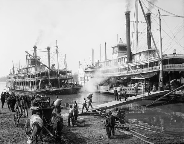
Riverboats being loaded at the Mississippi waterfront at Memphis, Tennessee in 1906.
During the 19th century steamboats played a major role in the transport of passengers and freight up and down the mighty Mississippi River. With the coming of the railroad, steamboats became less important for passenger transport (trains were faster). However, steamboats were still moving freight until the early 20th century.
Memphis was one of the great ports on the Mississippi. As it was was the slave port (the river port for the transhipment of slaves to the cotton plantations), it was greatly fought over during the Civil War.
It has been established by measurement and observation that the great bottom lands above Red River before the construction of their levees did not serve as reservoirs to diminish the maximum wave which passed through Louisiana in great flood seasons. They had already become filled by local rains and by water escaping into them from the Mississippi through numerous bayous, so that at the date of highest water the discharge into the river near their southern borders was fully equal to the volume which the wave had lost in passing along their fronts.
In fine, the investigations between 1850 and 1860 established that no diversion of tributaries was possible; that no reservoirs artificially constructed could keep back the spring freshets which caused the floods; that the making of cut-offs, which had sometimes been advocated as a measure of relief, so far from being beneficial, was in the highest degree injurious; that, while outlets within proper limits were theoretically advantageous, they were impracticable from the lack of suitable sites; and, finally, that levees properly constructed and judiciously placed would afford protection to the entire alluvial region.
During the civil war (1861-65) the artificial embankments were neglected ; but after its close large sums were expended by the States directly interested in repairing them. The work was done without concert upon defective plans, and a great flood early in. 1874 inundated the country, causing terrible suffering and loss. Congress, then in session, passed an Act creating a commission of five engineers to determine and report on the best system for the permanent reclamation of the entire alluvial region. Their report, rendered in 1875, endorsed the conclusions of that of 1861, and advocated a general levee system on each bank. This system, comprised—(1) a main embankment raised to specified heights sufficient to restrain the floods; and (2), where reasonable security against caving required considerable areas near the river to be thrown out, exterior levees of such a height as to exclude ordinary high waters but to allow free passage to great floods, which as a> rule only occur at intervals of five or six years. The back country would thus be securely protected, and a safe refuge would be provided for the inhabitants and domestic animals living upon the portion subject to occasional overflow. An engineering organization was proposed for constructing and maintaining these levees, and a detailed topographical survey was recommended to determine their precise location. Congress promptly approved and ordered the survey ; but strong opposition on constitutional grounds was raised to the construction of the levees by the Government.
In the meantime complaints began to be heard respecting the low-water navigation of the river below the mouth of the Ohio. Forty-three places above the mouth of Red River afforded depths of less than 10 feet, and thirteen places depths less than 5 feet, the aggregate length of such places being about 150 miles. A board of five army engineers, appointed in 1878 to consider a plan of relief, reported that 10 feet could probably be secured by narrowing the wide places to about S500 feet with hurdle work, brnsh. ropes, or brush dykes designed to cause a deposit of sediment, and by protecting caving banks, when necessary, by such light and cheap mattresses as experience should show to be best suited to the work. Experiments in these methods were soon begun upon the river above Cairo, and have since proved of decided benefit.
In June 1879 Congress created a commission of seven members to mature plans to correct, permanently determine, and deepen the. channel, to protect the banks of the river, to improve and give safety to navigation, to prevent destructive floods, and to promote and facilitate commerce. Up to 1882 appropriations amounting to £1,285,000 were made to execute the plans of this commission, but with provisos that none of the funds were to be expended in repairing or building levees for the protection of land against overflow, although such levees might be constructed if necessary to deepen the channel and improve navigation. Acting under this authority, the commission have allotted considerable sums to repair existing breaks in the levees ; but their chief dependence is upon contracting the channel at low water by promoting lateral deposits, and upon protecting the high-water banks against caving by mats of brush, wire, &c, ballasted where necessary with stone,—substantially the plans proposed by the army board of 1878.
The bars at the efflux of the passes at the mouth of the Mississippi have long been recognized as serious impediments to commerce. The river naturally discharges through three principal branches, the south-west pass, the south pass, and the north-east pass, the latter through two channels, the most northern of which is called Pass a l'Outre. The ruling depth on the several bars varies with the discharge over them, which in turn is controlled by the successive advances of the passes. In the natural condition the greatest. depth does not exceed 12 or 13 feet. The first appropriation by Congress to secure increased depth was made in 1837, and was expended in an elaborate survey and in a system of dredging by buckets, but the plan of a ship canal was also discussed. At the next appropriation, made in 1852, a board of officers, appointed by the war department, recommended trying in succession—(1) stirring up the bottom by suitable machinery, (2) dredging by buckets, (3) constructing parallel jetties 5 miles long at the south-west pass, to be extended as found necessary, (4) closing lateral outlets, and (5) constructing a ship canal. A depth of 18 feet was secured by the first plan, and was maintained until the available funds were exhausted. Under the next appropriation (1856) an abortive attempt was made to apply the plan of jetties to the south-west pass. This failed from defects in execution by the contractors, but a depth of 18 feet was finally secured by dredging and scraping. The report of 1861 discussed the subject of bar formation at length. Although it approved the plan of jetties and closure of outlets as correct in theory, the stirring up of the bottom by scrapers during the flood stages of the river (six months annually) was recommended by it as the most economical and least objectionable. After the war this recommendation was carried into effect for several years with improved machinery, giving at a moderate annual cost a depth at times reaching 20 feet at extreme low water, but experience indicated that not much more than 18 feet could be steadily maintained. This depth, entirely satisfactory at first, soon became insufficient to meet the growing demands of commerce, and in 1873 Major Howell, the engineer in charge, revived the project of a ship canal. The subject was discussed carefully by a board of army engineers, the majority approving a ship canal. In 1874 Congress constituted a special board which, after visiting Europe and examining similar works of improvement there, reported in favour of constructing jetties at the south pass, substantially upon the plan used by Mr Caland at the mouth of the Meuse ; and in March 1875 Captain J. B. Eads and associates were authorized by Congress to open by contract a broad and deep channel through the south pass upon the general plan proposed by this board. This contract called for " the maintenance of a channel of 30 feet in depth and 350 feet in width for twenty years " by "the construction of thoroughly substantial and permanent works by which said channel may be maintained for all time after their completion." The jetties were to be not less than 700 feet apart. The sum of £1,080,000 was to be paid for obtaining this channel, and £412,000 for maintaining it for twenty years. In addition, the contractors were authorized to use any materials on the public lands suitable for and needed in the work. The south pass was 12_____miles long. It had an average width of 730 feet and a minimum interior channel depth of 29 feet. The distance from the 30 foot curve inside the pass across the bar to the 30 foot curve outside was 11,900 feet. The minimum depth at average flood tide on the bar was about 8 feet. The discharge at the mouth was about 57,000 cubic feet of water per second, transporting annually about 22 million cubic yards of sediment in suspension to the Gulf. A small island and shoal existed at the head of the pass, the channel there having a minimum depth of 17 feet. The work was begun on June 2, 1875, and lias been so far successful that during the year ending June 30, 1882, a channel was maintained having a least depth of 30 feet between the jetties and extending through the bar. Its least width was 20 feet, the average being 105 feet. The 26 foot channel had a least width of 200 feet, except for a few days. In the pass itself the 26 foot channel had a least width of 50 feet. A very powerful dredge-boat was at work between and beyond the jetties 87 days, of which 51 were devoted to the channel in the Gulf. A deepening of 6 feet has occurred in Pass a l'Outre near its head since 1875. Up to the present time the work has proved of great benefit to the commerce of New Orleans.
For further details, see RIVER ENGINEERING. (H. L. A.)
Share this page:
|