1902 Encyclopedia > Mysore, India
MYSORE or MAISUR (i.e., Mahesh-asura, "Buffalo-demon") is a native state in southern India, lying between 11° 40’ and 15° N. lat. And 74° 40’ and 78o 30’ E. long., and surrounded entirely by British territory, with an area of 24,723 square miles. The Mysore country above the Ghatts, though frequently called "the tablehand," is by no means flat or a plain, but is in some parts mountainous and everywhere undulating. Deep ravines are situated in the angle where the Eastern and Western Ghats converge into the group of the Nilgiri hills. An interesting feature of the country is the large number of isolated rocks (drug, "difficult of access") which often rear their heads as stupendous monoliths to the height of 4000 or 5000 feet above sea-level. Some of these rocks – in particular nandidrug (4810 feet) and Savandrug (4024 feet) – have been the scene of many a hard-fought contest, while Kabaldrug obtained an evil fame as a state prison. The eight highest peaks in Mysore are Mulaina-giri (6317 feet), Kuduri-mukha (6215), Baba Budan-giri (6214), Kalhatti (6155), Rudra-giri (5692), Pushpa-giri (5626), Merti-gudda (5451), and Wodin-gudda (5006 feet). Five of these are comprised in the Baba Budan or Chandradrona range, a magnificent horse-shoe-shaped cluster of mountains. Mysore is naturally divided into two regions of distinct character-the hill country called the Malnad, on the west, and the more open country known as the Maidan, comprising the greater part of the state, where the wide-spreading valleys and plains are covered with villages and populous towns. The drainage of the country, with a slight exception, finds its way into the Bay of Bengal, and is divisible into three great river systems – that of the Krishna on the north, the Cauvery on the south, and the Pennair, Penar, and Palar on the east. A few minor streams flow west into the Arabians Sea. Owing to either rocky or shallow beds none of the Mysore rivers are navigable, but some are utilized for floating down timber at certainb seasons. The main streams, especially the Cauvery and its tributaries, support an extensive system of irrigation by means of channels drawn from immense dams (anicuts), which retain the water at a high level and permit only the overflow to pass down stream. The streams are embanked at every favorable point in such a manner as to form a series of reservoirs or tanks, the outflow from one at a higher level supplying the next lower, and so on, all down the course of the stream at short intervals. These tanks, varying in size from small ponds to extensive lakes, are dispersed throughout the country to the number of 20,000; the largest is the Sulukere Lake, 40 miles in circumference.
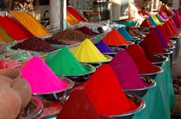
Indian spice vendor in the city market, Mysore, India
The census of 1881 returned the population of Mysore at 4,186,188 (males 2,085,842, females 2,100,346), viz., Hindus 3,956,336, Mohammedans 200,484, Christians 29, 249, :others" 119. The population of the chief towns in the executive districts was as follows: - Bangalore, 155,857; Mysore, 60,292; Shimoga, 12,040; Kolar, 11,172; Tumkur, 9909; Chikmagalur, 7088; Hassan, 5950; and Chitalchoog, 4271. In 1880-81 out of a total of 4,280,674 acres of cultivable land 3,139,560 were occupied by ragi and other dry crops, 554,752 by rice, 21,058 by wheat, 147,464 by oil-seeds, 24,076 by sugar cane, 20,893 by cotton, 159,165 by coffee, 135,542 by cocoa-nut and areca-nut, and the remainder by fibres, tobacco, vegetables, mulberry, pepper, and lac. Two cinchona plantations have been recently established, and promise good results. In the Lal Bagh or Government garden at Bangalore, attempts have been made with some success to grow vanilla, cocoa, rhea, ipecacuanha, and various other exotic plants, while the culture of apples, peaches, strawberries, and other fruits has been greatly improved.
The drought which affected all southern India in 1876-78 fell with especial severity upon Mysore. From October 1875 to October 1877 four successive monsoons failed to bring their full supply of rain. The harvest of 1875 was generally below the average, and remissions of revenue were found necessary; but it was not till the close of 1876 that actual famine occurred. During the whole of 1877 famine was at work; but in October of that year the monsoon broke with a fair rainfall, and cultivation at last became possible. It will, however, take many years before Mysore recovers its normal condition of prosperity; and it is estimated by competent authorities that one-fourth of the entire population of the state was swept away by starvation or disease, while the mortality among cattle was yet more heavy. In 1880-81 also 200,000 head of cattle perished. In September 1877, when affairs were at their worst, no less than 280,000 persons were in receipt of relief. The total amount expended on state relief, apart from loss of land revenue, was upwards of a million sterling.
The chief manufacture of Mysore is iron-smelting at Bangalore. Gold-mining is pursued in Kolar and Bangalore (since 1881) districts. Jewellery is a speciallity of Bangalore. Carpets, rugs, cotton textures, silk cloths, cumblies, &c., are also manufactured, the total estimated value being 6,281,651 rupees. Sandal-wood, which forms a state monopoly, yields an average annual income of about 15,000 pounds. the Madras railway runs through the state. An excellent net-work of provincial and district roads intersects the state, and great attention has been paid to the numerous passes through the Western Ghats to the low country beyond.
The total revenue for 1880-81 was 10,270,383 rupees. Local funds to the extent of 700,697 rupees were also levied for the maintenance of district roads and tanks, and for the support of village schools. Municipalities have been established at all district headquarters, and also in sixty-seven other towns. The system of judicial procedure, both civil and criminal, has been assimilated to that in force in British territory. Mysore pays a yearly subsidy to the British Government of 2,450,000 rupees for the maintenance of a force for the defence of its territory. There is also a local force. In 1880-81 the total number of schools of all classes in the state was 899 Government schools and 1881 aided schools, the total number of scholars being 42,657. There are in all 20 hospitals or dispensaries; the average daily attendance in 1880-81 was 1500.
In the earliest historical times the northern part of Mysore was held by the Kadamba dynasty, whose capital, Banwasi, is mentioned by Ptolemy; they reigned with more or less splendor during fourteen centuries, though latterly they became feudatories of the Chalukyas. The Cheras were contemporaries with the Kadambas, and governed the southern part of Mysore till they were subserted by the Cholas in the 8th century. Another ancient race, the Pallavas, held a small portion of the eastern side of Mysore, but were overcome by the Chalukyas in the 7th century A.D. These were overthrown in the 12th century by the Ballalas, an enterprising and warlike race professing the Jain faith. They ruled over the greater part of Mysore, and portions of the modern districts of Coimbatore, Salem, and Dharwar, with their capital at Dwarasamudra (the modern Halebid); but in 1310 the Ballala king wasn captured by Malik Kafur, the general of Ala-ud-din; and seventeen years later the town was entirely destroyed by another force sent by Muhammad Tughlak. After the subversion of the Ballala dynasty, a new and powerful Hindu sovereignty arose at Vijayanagar on the Tungabhadra (see India, vol. xii p. 794). In 1565 a confederation of the Mohammendan kingdom defeated the Vijayanagar sovereign, Raja Ram, at the battle of Talikot; and his descendants ultimately became extinct as a ruling house. During the feeble reign of the last king, the petty local chiefs (paligars) asserted their independence. The most important of these was the wodeyar (:lord") of Mysore, who in 1610 seized the fort of Seringapatam, and so laid the foundation of the present state. His fourth successory, Chikka Deva Raj, during a reign of thirty-four years, made his kingdom one of the most powerful in southern India. In the 18th century the famous Haidar Ali usurped the throne, and by his military prowess made himself one of the most powerful princes of India. His dynasty, however, was as brief as it was brilliant, and ended with the defeat and death of his son Tipu at Seringapatam in 1799. A representative of the ancient Hindu line was then replaced on the throne. Owing to his career of misgovernment, the British administration assumed the authority in his name in 1831. He died in 1868, leaving an adopted son, Chikka Krishna Arasu, a minor, during whose pupilage and training the state management was conducted by British officers. The full sovereignty of the state was handed over to him in March 1881.
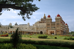
Amba Vilas Palace (built 1910-10) in Mysore, India
Mysore, the ancient capital of the above state, is situated 10 miles south-west of Seringapatam, in 12° 18’ N. lat and 76° 41’ E long., with a population of 60,292 in 1881. The town, which is spread over an area of about 3 square miles, lies at the foot of the Chamundi hill, in a valley formed by two parallel ridges running north and south. The streets generally are broad and regular, except in the fort. The majority of the houses are tiled, and some of them are substantial buildings two or three stories high. Altogether, the town has a clean and prosperous look, and its sanitary condition has been greatly improved of late years. The fort stands in the south of the town, forming a quarter by itself; the ground-plan is quadrangular, each of the sides being about 450 yards long. In the interior is the palace of the maharaja, built in an extravagant style of Hindu architecture, and adorned inside with a few paintings by a European artist, the principal object of interest being the throne, which is said to have been presented to Chikka Deva Raj by the emperor Aurangzeb. A new palace has been erected at Bangalore for the young maharaja. Opposite the western gate of the fort is a lofty and handsome building known as the Mohan Mahal, erected by the late maharaja for the entertainment of the European officers. The houses of the European residents are, for the most part, to the east of the town. The residency was built by Colonel Wilks in the beginning of this century. It has a handsome portico; and a room at the back, added by Sir John Malcolm, is said to be the largest in India. The building now used for the district offices was originally built by Colonel Wellesley (duke of Wellington) for his own occupation. Mysore was the capital of the state up till 1831, when on the British occupation the seat of administration was removed to Bangalore. (W. W. H.)
The above article was written by: W. W. Hunter, LL.D.
|