"The tides in the English Channel claim notice as having been the subject of careful examination by many persons, English and French. It appears that in the upper part of the Channel the water flows up the Channel nearly three hours after high water and runs down nearly three hours after low water (this continuance of the current after high water, if it last three hours, is called by sailors tide-and-half-tide; if it last one hour and a half, it is called tide-and-quarter-tide). On the English side of the Channel, especially opposite the entrance of bays, the directions of the currents turn in twelve hours in the same direction as the hands of a watch; on the French side they turn in the opposite direction. This is entirely in conformity with theory. The same laws are recognized as holding in the British [Bristol?] Channel, and in the German or North Sea near the Scotch and English coasts.
"With regard to the Irish Channel we have only to remark that there is a very great difference in the height of the tide on the different sides, the tide on the east side being considerably the greater. They are also greater in the northern part (north of Wirklow on one side, and of Bardsey Island on the other side) than in the southern part. Between Wexford and Wicklow they are very small.
"The tides of the German Sea present a very remarkable peculiarity. Along the eastern coast of England, as far as the mouth of the Thames, the tide-wave, coming from the Atlantic round the Orkney Islands, flows towards the south. Thus, on a certain day, it is high water in the Murray [Moray] Firth at eleven o’clock, at Berwick at two o’clock, at Flamborough Head at five o’clock, and so on to the entrance of the Thames. But on the Belgian and Dutch coasts immediately opposite, the tide-wave flows from the south towards the north. Thus, on the day that we have supposed, it will be high water off the Thames at eleven o’clock (the tide having travelled in twelve hours from the Murray Firth) and at Calais nearly at the same time; but at Ostend it will be at twelve, off The Hague at two, off the Helder at six, and so on.
"We believe that a complete explanation may be found in the arrangement of the great shoals of the North Sea. It must be remarked that (except within a very small distance of Norway) the North Sea is considerably deeper on the English side than on the German side; so much so that the tide-wave coming from the north runs into a deep bay of deep water, bounded on the west side by the Scotch and English coasts as far as Newcastle, and on the east side by the great Dogger Bank. As far as the latitude of Hull, the English side is still the deep one; and, though a species of channel through the shoal there allows an opening to the east, yet immediately on the south of it is the Wells Bank, which again contracts the deep channel to the English side. After this (that is, in the latitude of Yarmouth) the deep channel expands equally to both sides. It seems reasonable to conclude from this that the great set of north tide is on the English side of the North Sea, both between the Dogger Bank and England and between the Wells Bank and England (a branch stream of tide having been given off to the east between these two banks), and that any passage of tide-wave over these banks may be neglected. Now this view is supported in a remarkable degree by the tidal observations on two dangerous shoals called the Ower and Leman, lying between Cromer and the Wells Bank, but nearer to the latter. It appears that on these shoals the direction of the tide-current revolves in the same manner as the hands of a watch, proving conclusively that the Ower and Leman are on the left hand of the main stream of tide (supposing the face turned in the direction in which the tide proceeds), or are on its eastern border, and therefore that the central stream is still nearer to the coast of Norfolk. From a point not far south of this we may suppose the tide to diverge in a fan-shaped form over the uniformly deep Belgian Sea. Along the English coast the wave will flow to the south; but it will reach the whole of the Belgian and Dutch coast at the same instant; and, if this tide alone existed, we doubt not that the time of high water would be sensibly the same along the whole of that coast.
"But there is another tide of great magnitude, namely, that which comes from the English Channel through the Straits of Dover. This also diverges, we conceive, in a fan form, affecting the whole Belgian Sea: the western part turns into the estuary of the Thames; the eastern part runs along the Dutch coast, producing at successive times high water (even as combined with the North Sea tide) along successive points of that coast from Calais towards the Helder. And this we believe to be the complete explanation of the apparently opposite tide-currents. The branch tide of the North Sea running between the Dogger Bank and the Wells Bank will assist in propagating the tide along the German coast from the Holder towards the mouth of the Elbe. We have gone into some detail in this explanation for the purpose of showing the importance of considering the form of the bottom in explanations of specific tides.
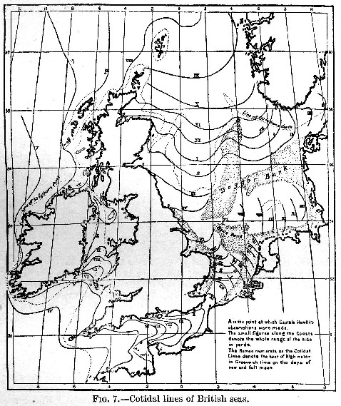
"A set of observations has been made by Captain Hewett (at the point A, fig. 7) on the depth and motion of the water at a strictly definite point a few miles south of the Wells Bank, near the middle of the Belgian Sea. The result was that the change of elevation of the surface was insensible, but that there was a considerable stream of tide alternately north-east and south-west (magnetic). The point in question corresponds pretty well to the intersection of the cotidal lines of nine o’clock of the North Sea tide and three o’clock of the English Channel tide (ordinary establishment), and these tides would therefore wholly or partially destroy each other as regards elevation. As regards the compound tide-stream, the greatest positive current from one tide will be combined with the greatest negative current of the other, and this will produce a stream whose direction agrees well with observation. At 3h on the day of new moon, the North Sea tide would be running north (magnetic), and the English Channel tide would be running east, and therefore the compound current would be running north-east; at 9h it would be running south-west. Both currents, and consequently the compound current, would cease at about Oh, 6h, &c., on the day of new moon; and, as the observations were made rather more than a day before new moon, the slack water would occur an hour or more before noon. The whole of this agrees well with the observations."
Read the rest of this article:
Tides - Table of Contents