Prince Henry the Navigator
The work of Prince Henry is well defined by his biographer, Mr. Major. Until his day the pathways of the human race had been the mountain, the river, and the plain, the strait, the lake, and the inland sea. It was he who first conceived the thought of opening a road through the unexplored ocean, -- a road replete with danger but abundant in promise.
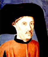
Born on March 4, 1394, Prince Henry was a younger son of King João of Portugal and of Philippa of Lancaster, the grandchild of Edward III; so that he was half an Englishman. Prince Henry relinquished the pleasures of the court, and took up his abode on the inhospitable promontory of Sagres, at the extreme south-western angle of Europe. To find the sea-path to the "thesauris Arabum et divitis Indiae" was the object ton which he devoted his life. He collected the information supplied by ancient geographers, unweariedly devoted himself to the study of navigators of every country. The prince’s motto was "Talent de bien faire," -- the word "talent," in those days, conveying not the idea of power of faculty, but of desire. Having acquired military renown by the capture of Ceuta in 1415, he set his mind upon the conquest of Guinea, and sent every year two or three vessels to examine the coasts beyond Cape Nun, which was then the limit of exploration. Yet none of his ships for many years had the hardihood to round Cape Bojador.
The first fruit of Prince Henry’s explorations was the rediscovery of Madeira and Porto Santo, in 1418 and 1420. The truth of the romantic story of the first discovery of Madeira by two English lovers named Robert Machim and Anna d’Arfet, in the time of Edward III, has been demonstrated by Mr. Major. Madeira and Porto Santo were granted to Prince Henry by his brother, King Duarte, in 1433. In the same year one of the prince’s ships, commanded by Gil Eannes, at length doubled Cape Bojador. In 1435 Affonso Gonsalves Baldaya, the prince’s cup-bearer, passed 50 leagues beyond the cape; and eight years afterwards Nuño Tristam got to a point 25 miles beyond Cape Blanco.
But it was not until 1445 that the mouth of the Senegal was reached by Diniz Dias; and in those days the Portuguese gave the name of Guinea to the country commencing at Cape Num. In 1481 the king of Portugal assumed the title of lord of Guinea. Up to 1446 there had been 51 caravels to the Guinea coast, and almost every year some new advance was made.
Meanwhile the Canaries and Azores were brought within the realms of Spain and Portugal. In 1402 a Norman named Jean de Bethencourt, accompanied by Gadifer de la Salle, had landed on the island of Lancarote, and with reinforcements from Spain he cubjugated Forteventura and Ferro, and received the sovereignty of the Canaries from the king of Castile. But he returned to his lands in Normandy in 1406, and died there in 1425. Gomera, Palma, Teneriffe, and the Great canary were still unconquered. Prince Henry made several attempts to establish Portuguese rule on these islands; the right was long disputed with Spain; and it was not until 1479 that the treaty of Alcacora provided for the concession of the sovereignty of the Canaries to Spain. Prince Henry, however, successfully colonized the Azores, and in 1444 St Michael’s was discovered, the settlement of the other islands following soon afterwards.
In 1455 an important expedition was dispatched by Prince Henry, under the command of young Venetian adventurer named Alvise Cadamosto. Touching at Madeira and the Canaries, Cadamosto made his way to Cape Blanco on the African coast, and thence to Senegal and the Gambia. He returned with a full report of all he had seen, and in the following year he again sailed from Lagos direct for Cape Blanco, with three ships, and discovered the mouth of a river which he named the Rio Grande (Jeba?). In 1457 Diogo Gomez sailed with orders to proceed as far as he could, and made his way to the Gambia. The Cape Verd Islands were discovered and colonized about 1462.
Prince Henry the Navigator died on the 13th of November 1460, and was buried near his father and month in the monastery of Batalha. In 1839 a monument to his memory was erected at Sagres. During the long period in which the prince was continuing his maritime explorations, he did not cease to cultivate the science of cartography. The geographer Jayme of Majorca superintended his school of navigation at Sagres, and at the prince’s instance the finest specimen of mediaeval map-making that has been preserved was prepared at Venice under the superintendence of Fra Mauro of the Camaldolese convent of San Miguel de Marano. The geographical knowledge of the 15th century is also shown by the famous Borgia map (see Plate II.), a bronze planisphere which came into the Possession of Cardinal Borgia about 1794, and was published in 1797 by the cardinal’s nephew. The Borgia map, however, is of the very beginning of the 15th century.
The progress of discovery for a time received a check from the death of Prince Henry, but only for a time. In 1462 Pedro de Cintra extended Portuguese exploration 600 miles beyond the furthest point reached by Cadamosto, and discovered Sierra Leone. Fernan Gomez followed in 1469, and opened the trade with the Gold Coast; and in 1484 Diogo Cam discovered the mouth of the Congo. The king of Portugal next dispatched two vessels of 50 tons in August 1486, under the command of Bartholomeu Dias, to continue discoveries southwards; while, in the following year, he sent Pedro de Covilham and Affonso de Payva to discover the country of Prester John. Dias succeeded in rounding the southern point of Africa, which he named Cabo Tormentoso; but king João II, foreseeing the realization of the long-sought passage to India, gave it the enduring name of the Cape of Good Hope. Dias returned to Lisbon in December 1487; meanwhile Payva had died at Cairo; but Covilhan, having that a Christian ruler reigned in the mountains of Ethiopia, penetrated into Abyssinia in 1490. He delivered the letter which João II. had addressed to Prester John to the negûs Alexander of Abyssinia, but he was detained by that prince and never allowed to leave the country.
The results westward and eastward of the exertions of Prince Henry were the discovery of America by Columbus and of the Cape route to India by Vasco da Gama.
Read the rest of this article:
Geography - Table of Contents