1902 Encyclopedia > River Nile
River Nile
NILE. This mighty river, which after a course of 3370 miles pours into the Mediterranean a low-water current of 61,500 cubic feet per second, has its cradle in the Victoria Nyanza, an enormous lake in Central Africa where the line of the equator is crossed by 32°, 33° and 34° of E. long., somewhere about 4000 feet above the sea. The Victoria Nyanza measures 230 miles from north to south and 220 from east to west. Its coast-line, which is very irregular, cannot be less than 2000 miles; its water area is estimated at 27,000 miles, and its very islands have an aggregate area of 1400 square miles. The physical features of the shores vary greatly from district to district. At the south-east corner is Speke Gulf, about 60 miles long, formed partly by a deep indentation of the mainland and partly by the peninsula island of Ukerewe, which is separated from the mainland by Rugisi or Rugeshi Strait, a narrow and shallow channel about _ mile long, overgrown with rushes, papyrus, and a fine network of grass which undulates beneath the foot. Bukindo is the chief village on the island, which forms the territory of a separate ruler. Its inhabitants murdered Lieutenant G. Shergold Smith, R.N., and Mr O’Neill, members of the 1876-77 expidition of the Church Misdionary Society. To the north of Ukerewe lies Ukara, for the most past barren, and with two rugged hills rising 200 or 300 feet. The natives average less than 5 feet in height (Wilson and Felkin, i. pp. 99-101). Along the south and south-west coasts is a whole series of Islands-notably, Komeh, Mysomeh, Bumbireh, and Bukerebe or Alice Island; but of much more importance is the great Sesse Archipelago off the coasts of western Uganda. At first entered on our maps as a single great island, it has turned out to be (according to King Mtesa’s possibly somewhat exaggerated syayement) a cluster of four hundred mostly inhabited islands, some of the largest being 10 to 15 miles in length and 3 to 4 miles in breadth. Clothed as they generally are with forest, and fringed along the shore with papyrus or low jungle, they often present scenes of the richest tropical luxuriance. Along the east half of the northern coast are a number of considerable islands such as Usuguru, and, at the head of Nepoleon Channel, Uvuma, famous for the canoe contest waged between its inhabitants and King Mtesa at Uganda, of which Mr Stanley was spectator. Ugingo, on the east coast, is a large island separated like Ukerewe by a narrow channel from the mainland. Though when its extent is taken into account Victoria Nyanza may be described as shallow in contrast to such basins as those of Tanganyika, the depth, especially on the eastern side, appears to be very considerable, Stanley giving 275 and even 580 feet not far from the shore. Of the affluents of the lake a few only require to be mentioned. The Shimiyu, which falls into the south side of Speke Gulf, was described by Stanley (march 1875) as magnificent flood a mile wide receiving the waters of the Monangah, the Luwamberii, and the Duma, and having a course of 300 miles. If this were the case it would take the southmost point of the Nile system as far at least as between 4° and 5° S. lat. But when Lieutenant Shergold Smith saw the Shimiyu in 1876 he found it a comparatively insignificant stream, and if the altitudes observed by Smith and Pearson be correct it cannot be the recipient of the Luwamberri and the Monangah. Instead of the Shimiyu, either the Wami (or Kiye) or the Muinguira (Isanga or Isanda), both of which flow into Jordans Creek, may be the southmost feeder of the Nile. Of much more importance as a tributary than any of these is the Kagera (of the waganda), otherwise known as the Kitangule, Kitangure (Burton), Tenure(Grant), or Alexandra Nile (Stanley), a river 450 feet wide and 85 feet deep at its mouth, with a strong current, apparently pouring into the lake more water than is carried off by Nile. It may be navigated for about 50 miles, and is believed to have its sources between 200 and 300 miles to the south-west. There are several lakes along its course-Lake Windermere, Lake Thema, and the larger Lake Alexandra not yet reached by Europeans.
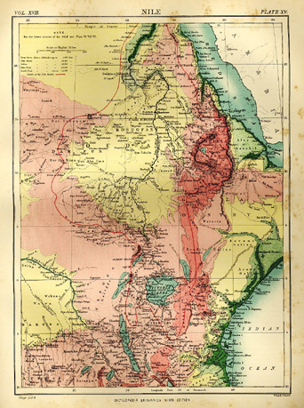
Map of River Nile
The leading fact in regard to the position of Victoria Nyanza in the general hydrography of Central Africa is that by none of its affluents is it connected with any of the other great "equatorial" lakes. Tangayika lies in a trough about 1400 feet lower. Between the Victoria and Lake Byassa (Zambesi system) there is a stretch of 500 miles; and, though a large lake, part of which Stanley saw in 1876, and named Gulf Beatrice, lies to the west, it forms in all probability a distinct basin.
In 1875 Stanley proved that the only outflow from Victoria Nyanza was by the Ripon falls on the north side of the lake. These falls (named after Earl de Grey and Ripon, president of the Royal Geographical Society in 1859) were discovered July 28, 1862, by aptain Speke, but from native accounts he was led to believe that other streams (such as the Luajerri) issued from the lake. The Nile, as it drops about 12 feet over the rocks, has a breadth of 400 to 500 feet, divided into several sections by a number of wooded isles. For the next 300 miles the Victoria Nile or Somerset River, as this section is called, has all the character of a mountain stream racing swiftly along rocky channel often walled in by cliffs (at times 180 feet high) and broken by picturesque islands and countless rapids. At first for 117 miles its course is north-north-west, but reaching he Khor kafu (on which Mruli stands), about 1° 38’ N. lat. And 32° 20’ E. long., it takes the north-east direction of this channel, and it is not till 2 o N. lat that it again turns north-west towards the Albert Nyanza. About 52 miles below the Ripon Falls, Long, who in 1874 boated from Urondogani to Foweira, describes himself as having passed through a lake 20 to 25 miles broad; but this expanse, which appears in text-books and maps (sometimes as two lakes, Kaya and Ibrahim Lakes), may have been the result of a mere temporary overflow. At Karuma, below Foweira, the river falls over a wall-like ledge of rock 5 feet high which extends right across its bed. But the great feature of the Victoria Nile is the Murchison Fall, about 2° 18’ N lat. and 31° 50’ E. long., where the river rages furiously through a rock-bound pass, and plunges at one leap of about 120 feet into a gloomy abyss. Below this point, continuing between steep forest-covered hills, it gradually calms down into a stream so slow and steady that at certain seasons it is only from the scarcely perceptible drifting of the little green water-plants, called Pistia Stratiotes, that the flow can be observed. About 20 or 25 miles below the fall it enters the north end of the Albert Nyanza.
This lake was first reached by Baker on March 14, 1864, near Vacovia on the east coast, a small village of fishermen and salt-makers. From a granitic cliff 1500 feet above the water he looked out over a boundless horizon on the south and south-west, and towards the west descried at a distance of 50 or 60 miles, blue mountains about 7000 feet high. The Albert Nyanza was consequently entered on his map as a vast lake extending from 2° S. lat. To 2° 50’ N. lat., or a distance of about 380 miles. But the circumnavigation of the lake by Gessi Pasha (1876), mason Bey, and Dr Emin Bey leaves no doubt that its real dimensions are – length 97 miles, average breadth 22 miles, and area about 2000 square miles. The western shore is in its northern half overhung by lofty and precipitous mountains, but farther south is formed by a wide forest-clad plain. At the south end the water is very shallow and encumbered by a vast stretch of ambatch forest. Instead of the lake being, as Baker contended, one of the great sources of the Nile, its functions are those of a large backwater. Of course a considerable amount of drainage must reach it from the surrounding high grounds, though the lakeward slopes are not very extensive; but none of its tributaries appear to be of much importance as feeders of the main stream. Along the western shore the depth is from 15 to 20 feet.
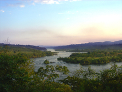
Source of the Nile.
This photo was taken at dusk looking southwards up the Nile near its source in Lake Victoria (also known as Victoria Nyanza), Uganda, which is widely accepted to be the main source of the Nile.
Escaping by an island-studded channel from the north-west corner of the Albert Nyanza, the Nile, which now takes the name of Bajr-al-Jebel, or River of the Mountains, continues to flow in a general northward direction. From Mangungo to Dufile (Duffli), 128 miles, its course is wonderfully smooth, and forms a series of lake-like reaches. Below Dufile the high lands close in upon the river, which, from a width of a mile at Dufile, narrows to 400 or 500 yards, and rushes through a gorge. Near Mugi (50 miles below Dufile) are the formidable Yarborah rapids. From Kiri (Kerrie) – an Egyptian fort on an eminence 1500 feet high on the left bank-the river is again navigable, but flows with so strong a current that Mr Felkin’s boat took only three and a half hours to reach Bedden, a distance of some 30 miles. At Bedden a line of hills runs right arthwart the channel, which is divided by an island of great beauty. An iron rope ferry was established by Gordon at this point, and without it the river could not be crossed. Between Bedden and Rejaf 912 miles) the hills give place to park-like plains dotted with large trees. about 15 miles below Rejaf, Gondokoro is passed on the right hand, and there the traveler may still see the ruins of the old mission church, the earthworks of Baker’s camp, and the lemon grove from which the fruit has been distributed throughout the equatorial provinces. At this point the river, about 656 feet wide, is divided by a large island. Eight miles farther down lies Lado (often spelled Lardo) on the left bank, a well-built Egyptian town with houses of burnt brick and a considerable area of cultivated land watered by shadufs. With the hill to the west of Lado, variously called Nyerkani and Luyola, the mountainous region ends, and the river enters on a vast plain. The affluents which it has hitherto received are for the most part short and individually insignificant khors (temporary streams), but two at least deserve a few words of description. The Unyama, joining the river opposite J. Kuku or Neri, 10 miles below Dufile, is a perential stream rising in the prairies between Fatiko and Unyoro, and winding through a lovely country for about 80 miles. The Asua (Atza of the Madi), whose mouth is 20 miles farthest down on the same side, is about 120 paces broad, and flows through a rocky bed 15 feet deep. As it receives nearly the whole drainage of the Madi and Shua countries and various districts farther east, it becomes in the rainy season a deep and furious torrent. The Atabbi or Atappi (the main drain of the western face of the Shuli mountains) reaches the Asua a short distance above the mouth.
The great plain which the Nile enters below Lado, about 5° N. lat., slopes so gradually towards the north that the river falls only 300 feet in a stretch of more than 650 miles between Gondokoro and Kahrtoum. As the river has gradually raised the level of both bed and banks, an overflow takes place, and lagoons or side channels (mayas) are formed wherever the bank breaks down; and as these, from their position, naturally act as settling-ponds they get rapidly silted up.
Up to about 7° 25’ N. lat., in spite of this condition of things, the Nile maintains a fairly definite course, with a considerable depth of water in its main current, but at this point it splits up into two branches as if to form a delta. The left branch, which retains the name Bahr al-Jebel, but which may be conveniently distinguished by the Denka name of Kir, continues in the line of the river, and the right branch, or Bahr al-Zeraf (Giraffe River), tends rather more towards the east. After flowing respectively about 160 and 140 miles, they reach the Bahr-al-Ghazal, slowly gliding east with a slight deflexion to the south. The whole region is a vast expanse of low swampy lands crossed by secondary channels, and flooded for many miles in the rainy season. At the junction of the Bahr al-Ghazal and the Kir the permanently submerged area is usually named Lake No on our maps, but the Arabs simply call it the confluence – Mokren al-Bohur. The scenes presented by this portion of the Nile are of the most peculiar description. The dark and ill-smelling water shows no sign of motion. On all sides stretch monotonous reaches of omm suf (i.e., woolly) grass (Vossia procera) and papyrus, rising 20 or 30 feet above the water so as often to close the view like a stone wall; the level of the plain is broken only at intervals by little mounds of earth, tenanted for the most part by white ants, and covered, with a clump of brushwood or trees; the moisture in the air is so excessive that gunpowder left in the guns overnight is reduced to a paste; mosquitoes and other swamp flies swarm in myriads. And yet touches of beauty are not wanting. Water-lilies (Nymphaea stellata and Nymphaea Lotus) – white, blue, and crimson-often adorn the surface of the stream; multitudes of water-fowl, from the familiar Egyptian duck and the pelican to the rare and odd-looking Balaeniceps rex (abu markub), breed among the reeds, and at night the scene is lit up by a very firmament of fire-flies.
Previous to 1863 both the Kir and the Bahr al-Zeraf had been navigable within the memory of man. But when the Tinne expedition passed down the river in March of that year, the white Nile, the united current of the Bahr al-Jebel and the Bahr al-Ghazal, was found to be blocked by an accumulation of vegetable flotsam, and it cost the crew two days’ hard labor to take their vessel through a channel partially cleared by their predecessors. The obstruction rapidly increased, and thirty vessels had to be employed for five weeks to open a permanent passage. In 1865 Baker found a dam about _ of a mile wide already overgrown with reeds and grass so as to form a continuation of the surrounding country. Matters went from bad to worse, and the White Nile, the Kir, and the Bahr al-Zeraf were all rendered impassable till, in 1874, ismael Ayub Pasha cleared the main route by the White Nile and the Kir. But in 1878 again the whole Nile rose to an unusual height (the banks at Lado, 15 to 20 feet above the mean level, were overflow), and enormous quantities of vegetable debris were carried off by the current. A formation of bars on an unprecedented scale was the result, and communication between the upper and lower Nile was not restored till 1880.
If the Kir and the White Nile, with their comparatively strong current, were thus obstructed, it was natural that the more sluggish Bahr al-Ghazal should contain more extensive though less compact accumulations. In 1881 Gessi Pasha spent three and a half months on a part of the voyage usually performed in five hours, and lost half of his men by starvation. Between the mouths of the Kir and Bahr at-Arab there were twenty distinct dams.
Sir Samuel Baker asserted in 1874 that from the equator to the Mediterranean not a drop of water reached the Nile from the west, - the Bahr al-Ghazal being only a channel of stagnant pools and marshes (Proc. Rov geog. Soc., 1873-74, p. 148). But if their total contribution be of little moment in comparison with that if their eastern rivals, the western affluents are exceedingly numerous, and drain a wide extent of country. Their relative importance has been shown by Schweinfurth, Junker, Emin Bey, &c. One or two – the Rodi (Lau) and the Rohl-join the Bahr al-Jebel in its passage through the plain, but by far the greater number converge to the Bahr al-Ghazal. At its lowest state, just before the commencement of the rains, this river had in 1881 a depth varying from 20 to 25 feet, though in many places no perceptible current. It is generally navigable to Meshrat-el-Rek, about 200 or 220 miles above the mouth of the Kir, and in the rainy season even small steamers may ascend its tributary, the Dyur or Jur, as far as Wau. In exceptionally dry seasons the channel at Meshrat-el-Rek is so utterly desiccated that drinking-water can be obtained only by digging. One of the main feeders of the Bahr al-Ghazal is the Bahr al-Arab, which is formed by the drainage of southern Darfur, has a breadth-about 10° 20’ N. lat. and 25° 20’ E. long. (before it receives any of its right hand affluents) – of 360 feet and a depth (in December) of 4 feet, and never quite dries up even in the heat of summer (Felkin, Uganda, ii. 239). This is the only considerable accession from the north: the rest of the affluents, an almost countless host if all the small headstreams be included, have their rise in the range of mountainous country which stretches, from the Blue Mountains of the Albert Nyanza and their southern continuation, in a general north-east direction as far as 25° or 26° E. long., and forms the watershed between the Nile basin and those probably of Lake Chad and the Congo. Flowing in many cases for 400 or 500 miles, these streams in the upper part of their course are of considerable volume and of much importance in the economy of the countries which they traverse.
About 95 miles below the junction of the Kir, and 30 below that of the Bahr al-Zeraf, the White Nile receives its first great affluent from the east. The Sobat, as it is called, has it headwaters (largely unexplored) distributed over a wide area- the southmost rising possibly as far south as 4° N. lat. In the hilly country of Atuka, the eastmost in Kaffa, and the northmost about 9° in the Berta mountains. On one of them there is probably a considerable lake: first inserted as Baro Lake on our maps by Petermann on the report of a slave dealer; it was expunged by Matteuci; but Schuver claims to have seen it from the mountains to the north, and proposes to call it Haarlem Lake. The Sobat proper is navigable from June to November as far as Nasser (180 miles), an Egyptian port established by Gordon in 1874, and even, it is said, for three days farther, though it divides into four branches a short distance above this point. Junker, who visited Naser in 1876, found the river 15 to 20 feet deep, flowing at the rate of 80 paces per minute between banks high enough to prevent any general inundation. At the mouth of the Sobat there is an Egyptian post of the same name (see Zeitschr. Der Ges. F. Erdk. Berlin, 1877).
The northward progress of the White Nile for the next 300 miles is through a great plain stretching from the spurs of the Abyssinian highlands in the east to the hilly districts of Takalla and Kordofan in the west, and consisting almost exclusively of red and other sandstone, often flat as a pavement. Escaping from the swampy region, the river again forms a well-marked channel, with regular and sometimes high banks. Throughout the whole distance indicated a striking confirmation of Baer’s law is afforded, - the fairway or deeper side of the stream generally keeping to the eastern shore. About 60 miles below the sobat mouth lies (on the right bank) Fashoda, an Egyptian town founded in 1867 on the site of Denab, the old "capital" of the Shilluks. In the neighborhood of Mahadat Abu Zaid (about 13° 5’ N. lat) begin the Sunt Islands, so called from the Arab name for the Acacia nilotoca, a tree characteristic of the white Nile.
At Khartoum (Khartum), in 15 o 37’ N. lat., the White Nile is joined by its greatest eastern confluent the Blue Nile (Bahr el-Azrak). This river has its head reservoir in Lake Tana (Tsana), which is so situated that the lines of 12° N. lat. and 37° 2’ E. long. Cut it into four nearly equal portions. The height of the lake is 5658 feet (Rohlfs). From east to west the breadth is about 40 miles, and the area is estimated at 2980 square miles. Between Dega and Zegi a depth of 236 feet has been found, and between Korata and Zegi 219. the Blue Nile, or Abai as it is called in Abyssinia, rises on the northward slopes of a cluster of mountains (Mouth Gesh, &c) about 11° N. lat. and flowing northwards enters Lake Tana near the south-west corner, to issue again at no great distance. Of the multitudinous ramifications by which the Abai and its tributaries drain a large part of the Abyssinian plateau, a better idea will be obtained from the map than from any description. From east and south and north the mountain streams pour down into the river, - its Eastmost tributary probably rising east of Magdala, and its Southmost between 8° and 9° N. lat. At Fazokl or Famaka, 11° 17’ N. lat., it begins to escape from the mountains; about 130 miles farther down, after passing Rosaires and Karkoj on the right and Sennar on the left, it is joined by the Dinderl and 35 miles more bring it to the confluence of the Rahad (Ra’ad) and the town of Abu Haraz. Beyond this point it flows through the most fertile portion of the Egyptian Soudan, the plain on the left hand more especially being a great grain-growing district. The total length of the Abai or Blue Nile may be estimated at 960 miles.
On the north-west side of the mountains which enclose Lake Tana are some of the headwaters of the Atbara, another important tributary of the Nile; but it does not reach the main stream till about 17° 41’ N. lat., or 200 miles below Khartoum. Its principal branch, the Settit or Takazze, has a course of about 420 miles through the Abyssinian plateau before it joins or (more strictly) is joined by the river which gives its name to the united stream. The Khor-el-Gash, or Mareb, though a considerable river in its upper regions, reaches the Atbara (and thus the Nile, of which it is the northmost affluent only during a heavy rainy season (see James, Wild Tribes of the Soudan, 1883). A large number of these eastern tributaries are mountain torrents, of enormous volume and impetuosity during the rains, and for a short time afterwards, but rapidly dwindling again into mere threads of water or chains of pools, and leaving the rocks and sand of their deep-cut channels as dry and parched as the surrounding desert. No one who has read it will easily forget Sir Samuel Baker’s graphic account of the deep pool in the bed of the Atbara into which the fishes, tortoises, crocodiles, and hippopotami from a long reach of the river had gradually been crowded a the water disappeared, and of the sudden release effected by the return of the rainy season. A more recent traveler, Herr Schuver, had a similar experience on the Tumat, the southern tributary of the Blue Nile.
After receiving the Atbara the Nile continues for 650 miles through the Nubian desert, where the volume of the river suffers continual diminution from the extreme dryness of the air, without being recruited by a single drop of water. between Berber (an important town on the right bank 30 miles below the Atbara) and Wady Halfa (about 600 miles) rapids and cataracts follow at intervals. The highest of these, the fifth cataract of the Nile, is situated about 40 miles below Berber, the fourth, 170 miles farther down, below Shitab, the third, 230 miles farther, at Hannek, and the second just above Wady Halfa. At Assuan (200 miles lower) are the first cataracts. Beyond that point the river flows through the wonderful valley which has already been described in the article EGYPT.
Reduced to its simplest expression, the Nile system may be said to consist of a great steady flowing river fed by the rains of the tropics, controlled by the existence of a vast reservoir and several areas of repose, and annually flooded by the accession of a great body of water with which its eastern tributaries are flushed. The following details will enable the reader to estimate the hydrographic value of the different portions:-
Victoria Nyanza lies in a zone where rain falls all the year round. At Kagei (south shore) the lake was seen by Mr Wilson in 1877 to be slowly rising in the middle of February, and it had attained its maximum (2 feet) about the middle of May, ten days after the rain had ceased. The total rainfall of this zone is not excessive. Speke’s estimate of 49 inches is confirmed by Mr Wilson’s much longer experience. In Uganda there are two maximum periods – March to may, and September to November.
The Assua is important from 15th April to 15th November.
The Bahr al-Jebel, at Gondokoro, begins to rise in April, and gradually attains a maximum of 4 _ feet, the river being then 6 to 10 feet deep.
On the Kir the rainy season lasts from the first week of March to the close of October; but the 100 inches of rainfall goes largely to flood the swamps.
The bahr al-Ghazal is at its lowest in March, and begins to rise soon after.
The Sobat is full from June to December.
The White Nile, at Khartoum, begins to rise in May, but only gains 2 or 3 feet till July or August. Its maximum (6 feet) is reached in September. Linand Bey estimated its volume at low level as 10,488 cubic feet, and in flood as 213,450.
The Blue Nile, at Khartoum, begins to rise in July, and reaches its maximum (17 _ feet) by August 20. its rise is much more rapid than its decline; it takes eighty days to lose the gain achieved in fifty-one. Linant Bey estimated its volume at low level as 5615 cubic feet, and in flood as 220,620. at Famaka it grows turbid about 20th May.
The Atbara, for 150 miles above its junction with the Nile, is perfectly dry from March to June.
As a waterway leading into the heart of Africa, the Nile at first sight might appear to be of more importance than it is. Steamers, it is true, as well as sailing craft, can pass up from Egypt as far as Bedden, a distance of 2900 miles; but even at the period of high water (June to august) the ascend of the cataracts between wady Halfa and Berber is so dangerous for vessels of any size that the river-route is seldom followed throughout. From Wady Halfa the traveler may proceed by camel to el Ordeh (New Dongola), thence take boat to El Dabbeh or to Old Dongola, and again proceed by land either to Berber, Shendy, or Khartoum. Or, instead, he may leave the river at Korosko, and strike through the Nubian desert direct to Berber. From Berber, which is also the terminus of a route often used from Souakin) on the Red Sea, steamers ply up the river, but it sometimes takes nineteen days to reach Khartoum. The difficulties of navigating the Kir have already been described. Above Bedden the steamer again finds a free course from Dufile to the neighborhood of the Murchison Fall; but the route to Victoria Nyanza is again overland from Magungo. It is found more expeditious to come to the equatorial regions from the east coast than up the Nile valley.
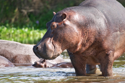
Wild hippopotamus by the Nile River
For the botanical aspects of the Nile valley the reader is referred to Schweinfurth’s papers (Petermann’s Mittheilungen, 1868); for the general zoology to Heuglin’s sketch (Ibid., 1869); and for an account of the fish fauna to Dr Gunther’s appendix to Mr and Mrs Petherick’s Travels in Central Africa (1869).
The ancients knew litte of the course of the Nile above MEROE (q.v.) Juba, in his Libyea, quoted by Pliny, makes the Nile rise in western Mauretania, not far from, the ocean, in a lake presenting characteristic Nile fauna, then pass underground for several days’ journey to a similar lake in Mauretania Caesariensis, again continue underground for twenty days’ journey to the source called Nigris on the borders of Africa and Ethiopia, and thence flow through Ethiopia as the Astapus. This tissue of invention received strange favor in the eyes of many subsequent geographers, and actually left its traces in some of our maps down to a comparatively modern time. Strabo, who ascended the river as far as Syene, states that very early investigators had connected the inundation of the lower Nile with summer rains on the far southern mountains, and that their theory had been confirmed by the observations of travelers under the Ptolemies. Nero dispatched two centurions on an expedition for the express purpose of exploring the Nile, and Seneca informs us that they reached a marshy impassable region, which may be easily identified with the country of the White Nile above the mouth of the Sobat. To what they referred when they reported a great mass of water falling from between two rocks is not so readily determined. By the time of Ptolemy information had somewhat accumulated. Two streams, he says, issuing from two lakes (one is 6° and the other in 7° S. lat), unite in 2° N. lat. To make the Nile which in 12° N. receives the Astapus a river flowing from Lake Coloe (on the equator). Thus it would appear that he had heard vaguely about the lakes which we know as Vitoria Nyanza, Albert Nyanza, and Tana. Hi two southern lakes, he conceived, were fed by the melting of snows on a range of mountains running east and west for upwards of 500 miles – the Mountains of the Moon , Lunae Montes. To this opinion he was probably led by hearsay about the snow-clad summits of Kilimanjaro and Kenia. On all the subsequent history of the geography of the Nile Ptolomy’s theory had an enormous influence. Mediaeval maps and descriptions, both European and Arabian, reproduce the Mountains of the Moon and the equatorial lakes with a variety of probable or impossible modifications. Even Speke congratulated himself on identifying the old Ptolemean range with the high lands to the north of Tanganyika, and connected the name with that of Unyamwezi, the "country of the moon." Attacking the lake region from the east coast, the Portuguese explorers gained a good deal of information which found its way into such maps as those of Pigafetta (1580); but it was not till the present century that the geography of those parts was placed on the basis of fully accepted observations. On November 14, 1770, Bruce reached Lake Tana, and considering, as he did, that the Blue Nile was the main branch, very fairly claimed for himself the honor of being the discoverer of the long-sought caput Nili.
The following are a few of the chief dates in the progress of knowledge since 1800 in regard to the river system:-
1807. Completion of Jaconti’s Atlas de l’Egypte (surveys from the Mediterranean to Assuan). 1814. Burchhardt goes up the Nile, partly by land, as far as Shendi, crosses to the Atbara, and skirts the east side to Gos Rajeb. 1819, Cailliaud is the first to visit Meroe. 1820, Steamers first ascend the cataracts to Korosko. 1822. Caiulliaud and Letorzec ascend the Blue Nile with Ibrahim Pasha’s military expedition as far as Fazokl. 1827, Limant Bey ascends White Nile 132 geographical miles to Al Ais, in 13° 43’ N. lat. Prokesch von Osten surveys the Nile between Assuan and Wady Halfa. 1839. Mehemet Ali sends up White Nile an expedition, usually known as the First Egyptian Egyptian Expedition, under Selim Birubashi, which (28th January 1840) reaches an island Badelik, in 6° 30’ N. lat., but adds little information. Thibaut (Ibrahim Effendi) was a member of this expedition. 1840-41. A second Egyptian expedition (D’Arnaud, Sabatier, Werne) reaches island of Janker near Gondokoro, about 4° 42’ N. lat. 1841-42. Third Egyptian expedition (Selim Bimbashi, D’Arnaud, Sabatier, Thibaut). 1845. Brun-Rollet founds trading post not far from subsequent site of Heiligenkreuz. 1846. First steamboat on White Nile. 1849. Baron Von Muller surveys the Nile from Handak to Ambakol in province of Dongola. 1850. Knoblecher (of Austrian mission) reached Log-wek. 1855. Rebmann (missionary at Kisulutini, north-west of Mombasa) sends home map showing Lake Ukerewe, extending from 0o 30/ N. lat. To 13° 30’ S. lat. 1858. Speke, twenty marches north of Kazeh, where he had left Burton, reaches shore of Victoria Nyanza. 1859, Miani reaches mouth of Unyama. 1860. Pruyssenaere starts from Khartoum up the White Nile. 1862. Speke reaches Ripon Falls. Steudner passes down the Ra’ad and Blue Nile to Khartoum. The Tinne expedition goes five hours’ journey beyond Gondokoro on the white Nile. 1864. Sir Samuel Baker reaches Albert Nyanza. Petherick closes a long series of wandering in the White Nile and Bahr al-Ghazal districts. 1868-71. Schweinfurth explores the western affluents of White Nile. 1871-73. Baker in the White Nile region. 1874. Watson and Chippendall survey the river from Khartoum to Rejaf, and J. Kemp from Rejaf to Dufile. 1875. Stanley circumnavigates Victoria Nyanza. 1877. First voyage across Victoria Nyanza by Rev. C.Y. Wilson and Lieutenant Shergold Smith. 1881-82. Schuver in the source district of the Tumat. (H. A. W.)
The article above was written by: Hugh A. Webster, formerly Librarian, Edinburgh University; editor of the Scottish Geographical Magazine; sub-editor of the Encyclopaedia Britannica.
|