1902 Encyclopedia > Africa > African Rivers
Africa
(Part 7)
(C) AFRICA - GEOGRAPHY (cont'd)
(f) African Rivers. Rivers - Africa.
Taking a broad view of the hydrography of Africa, there are two great areas of continental drainage, one in the north, the other in the south, from which no water escapes directly to the ocean. These correspond almost exactly with the two desert belts of the Sahara and the Kalahari above described. The whole of the remaining portions of the continent, its forests and pastoral districts, in which the greater rainfall gives greater power to the rivers, are drained by streams which find their way to the ocean on one side or other, generally forcing a passage through some natural or waterworn gorge in the higher circle of mountains which run round the outer edges of the great plateau.
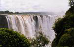
Victoria Falls on the Zambesi River
(on the border of Zimbabwe and Zambia)
By far the larger portion of the oceanic drainage of the continent is to the Atlantic and its branch the Mediterranean, to which the Nile, Niger, Ogowai, Congo, and Orange rivers flow. The great rivers which drain on the opposite side, to the Indian Ocean, are the Juba, Zambesi (or Zambeze), and Limpopo; whilst the northern continental basin, by far more extensive than the southern, has only one great river, the Shari, which supplies Lake Chad.
It must be noticed that the capabilities of the African rivers, as highways of approach to the interior of the continent, are exceedingly small in comparison with those of the other great continents of the globe, most of them being either barred at their mouths, or by rapids at no great distance from the coast. It is owing to this physical cause mainly that the African continent has remained for so many centuries a sealed book to the civilized world. On the other hand, it must be observed, that when these outer barriers have been passed, the great interior of the land, in its most productive regions, possesses a network of vast rivers and lakes, unsurpassed in extent by those of any country of the world, by means of which the resources of Central Africa may in future be thoroughly developed.
The Nile is the oldest of historical rivers, and afforded the only means of subsistence to the earliest civilized people on earth, and yet the origin of this river remained an enigma almost to the present day. though it drains a larger area than any other river of Africa, upwards of 1,000,000 square miles, and in this respect is one of the largest rivers of the globe, the Nile, passing for a great portion of its lower course through the desert belt of North Africa, and receiving no tributaries there, loses much of its volume by evaporation, and is far surpassed in the quantity of water conveyed to the ocean by the Congo , in the moist equatorial zone. The great labours of Dr Livingstone, in the lake region of Central Africa, have so narrowed the space within which the sources of the Nile can exist, that, though no traveller has yet reached the ultimate feeders of the great river, their position can now be predicated almost with certainty. The limit of the Nile basin on the south is formed by the high mountains which rise to westward of the Albert Lake, and which divide between this great reservoir and the Tanganyika, extending eastward to the plateau of Unyamuezi, on the northern side of which the Victoria Nyanza lies. The ultimate sources must then be the feeders of these great equatorial lakes, the Victoria and Albert. The river issuing from the former lake, at the Ripon Falls, 3300 feet above the sea, to join the northern end of the Albert Nyanza, may be considered as the first appearance of the Nile as a river. At the Ripon falls the overflow is from 400 to 500 feet in breadth, and the descent of 12 feet is broken in three places by rocks. Further down where the river turns westward to join the Albert Lake, it forms the Karuma and Murchison Falls, the latter being 120 feet in height . from the Albert Lake, the Nile, called the Kir in this part, begins its almost due northward course to the Mediterranean, and has no further lake expansion. Between the Albert and Gondokoro, in 5° N. lat., which lies at 2000 feet above the sea, the Nile descends at least 500 feet in a series of rapids and cataracts. Beyond Gondokoro, up to which point it is navigable, it enters the northern lower land of Africa, which is here a region of swamps and forests, and several tributaries join it from the west. The largest of these, named at Bahr-el-Ghazal, unites with the main stream below the 10th parallel; and, not much further on, a main tributary, the Sobat river, joins the Nile from the unknown region which lies to the southeast. Hence, onward, the Nile is known as the Bahr-el-Abiad or White River. The two remaining great tributary rivers descend from the high land of Abyssinia on the east. The first of these, the Bahr-el-Azrek or Blue River, its waters being pure in comparison with those of the Nile, has its source near Lake Dembea or Tzana, through which it flows, in the western side of the Abyssinian plateau, 6000 feet above the sea; forming a semicircular curve in the plateau, the Blue Nile runs north-westward to the confluence at Khartum, 1345 feet above the sea. Between this point and the union of the next tributary, the Nile forms the cataracts which is known as the sixth from its mouth. In about 18° N, it is joined by the Atbara or Black River, the head stream of which is the Takkazze, flowing in a deep cut valley of the high land. This tributary is named from the dark mud which it carries from the high land, brought down to it by streams which swell into rushing torrents in the rainy season. It is to these rivers that the fertility of Lower Egypt is mainly due, for each year a vast quantity of Abyssinian mud is borne down to be spread over the delta. Hence the Nile pursues its way in a single line through the dry belt of desert to the Mediterranean without a single tributary, descending by five cataracts, at considerable distances apart. The delta of the Nile, in which the river divides into two main branches, from which a multitude of canals are drawn off, is a wide low plain, occupying an area of about 9000 square miles. The most remarkable circumstance connected with the delta is the annual rise and overflow of the river, which takes place with the greatest regularity in time and equality in amount, beginning at the end of June, and subsiding completely before the end of November, leaving over the whole delta a layer of rich fertilizing slime.
Streams from the Plateau of Barbary
The Sheliff in Algeria, and the Muluya in Eastern Marocco, are the chief streams flowing to the Mediterranean from the high land of Barbary.
Passing round to the Atlantic system, the Sebu, the Ummer Rebia, and the tensift, from the Atlas range, are permanent rivers flowing across the fertile plain of Western Marocco, which they serve to irrigate. Next is the Wady Draa, a water-course which has its rise on the inner slope of the high land I n Marocco, and which bends round through the maroccan Sahara to the Atlantic, near the 28th parallel. Its channel, of not less than 500 miles in length, forms a long oasis in the partly desert country through which it flows, and water remains in its bed nearly throughout the year.
A stretch of 1100 miles of waterless coast, where the desert belt touches on the Atlantic, intervene between the Draa and the Senegal river, at the beginning of the pastoral belt in lat. 15° N.
Senegal River
The Senegal rises in the northern portion of the belt of mountains which skirt the guinea coast, and has a northwesterly course to the sea. During the rainy season it is navigable for 500 miles, from its mouth to the cataract of Feloo, for vessels drawing 12 feet of water, but at other times it is not passable for more than a third part of this distance.
Gambia River
The Gambia has its sources near those of the Senegal, and flows westward in a tortuous bed over the plain country, giving a navigable channel of 400 miles, up to the falls of Barra Kunda. The Rio Grande, from the same heights, is also a considerable river.
Niger River
The Niger is the third African river in point of area of drainage and volume; it is formed by the union of two great tributaries, the Quorra and Benue,- the former from the west, the latter from the country in the east of the river basin. The Quorra, called the Joliba in its upper course, has its springs in the inner slope of the mountains which give rise to the Senegal and Gambia, not far from the Atlantic coast. At first its course is north-eastward to as far as the city of Timbuctu, on the border of the desert zone; then it turns due east, and afterwards south-east to its confluence with the Benue, at a point 200 miles north from the coast of the gulf of Guinea. The chief tributary of the Quorra is the Sokoto river, coming from the elevated country which forms the water-parting between the Niger basin and that of Lake Chad on the east, and its confluence is near the middle of the portion of the channel of the Quorra which bends to south-east.
At a distance of about 100 miles from its sources, the traveller Park, the first European who reached the Joliba, found it flowing in a wide fertile valley, and navigated by canoes which kept up a constant traffic. Above Timbuctu the commerce of the river is busily carried on in barges of 60 to 80 tons burden; further on, where the river touches upon the desert belt in the most northerly portion of its course, its fertile banks form the most marked contrast to the arid desert lands beyond. From the confluence of the Sokoto to the union with the Benue, the river course is only navigable after the rainy season, since at other times rocks and shoals interrupt the passage. The sources of the Benue are unknown as yet, but it is believed to have its rise in the northern edge of the great plateau of Southern Africa, almost due south of Lake Chad; its known course is westward, and at the furthest point to which it was easily navigated by the traveller Baikie, nearly 400 miles from its confluence with the Kawara or Quorra, it was still half a mile in width and about ten feet in average depth, flowing through rich plains. From the confluence of the Quorra and Benue the Niger has a due south course to its delta, and the united river has an average width of about a mile. At a distance of 100 miles from the sea, minor branches which enclose the delta separate from the main stream on each side. The delta is much more extensive than that of the Nile, and measures about 14,000 square miles of low alluvial plain, covered with forest and jungle, and completely intersected by branches from the main river, the outmost of which reach the sea not less than 200 miles apart. Unlike the Nile, the Niger possesses one main channel through the centre of the delta, called at its mouth the Nun river.
Gaboon River
Old Calabar river, the camaroon river, and the Gaboon, are the best known of a number of wide inlets or estuaries of the sea, which occur on the west coast immediately north of the equator; but these are merely the receptacles of a number of minor streams, not the mouths of great rivers, as at one time supposed.
Ogowai River
The Ogowai (pron. Ogowee) river, the delta of which forms Cape Lopez, immediately S. of the equator, is a great stream which is belived to drain a large area of the forest zone between the Niger and the Congo; as yet, its lower coast is only known to a distance of 200 miles from the sea. Above the delta the main stream of the river, named the Okanda, breaks through the edge of the plateau, and is joined by the Onango, a tributary from the coast range of the Sierra Complida. Below this confluence the river is a mile and a half in average width, its depth varying from 15 to 50 feet. The delta is formed by the two main branches into which the Ogowai divides at about 30 miles from the coast, and is a swampy flat, covered with mangroves.
Congo River
The Congo or Zaire must be considered the second river of Africa in point of area of drainage, and it is the first in respect of the volume o water which it discharges to the ocean. There remains but little doubt that the head streams of this vast river are those which supply the great lacustrine system discovered by Dr Livingstone in his recent journeys south and west of Lake Tanganyika. Through these lakes the river, which rises in the upland north of Lake Nyassa, named in different parts of its course the Chambeze, Luapula, or Lyalaba, flows in great bends to west and northward to where it passes into the unknown country still to be explored in the heart of the continent. The Lualaba has a great tributary named the Lufira, from the south; and it is almost certain that the Kassabi river, which springs in the Mossamba Mountains, in the interior borders of Angola, is also one of the feeders of this great river. The Guango river, rising in the same mountains, nearer Angola, must also join the Congo lower down in its valley. At the furthest point on the Lualaba reached by Livingstone, in about lat. 6° S. and long. 25° E., the great river had a breadth of from 2000 to 6000 yards, and could not be forded at any season of the year. Every circumstance connected with this river-its direction, the time of its annual rising, and the volume of its water which could be discharged by the Congo mouth alone-point to its identity with this river. The explorer Tuckey, who, in 1816, followed up the Congo from its mouth on the west coast further than any one, found it, above the cataracts which it forms in breaking through the coast range, to have a width of from 2 to 4 English miles, and with a current of from 2 to 3 miles an hour; and his statement that at the lowest stage of its waters it discharges 2,000,000 of cubic feet of water per second has been confirmed by more recent surveys. Forty miles out from its mouth its waters are only partially mingled with that of the sea, and some nine miles from the coast they are still perfectly fresh. The Congo is the only one of the large African rivers which has any approach to an estuary, contrasting in this respect with those which have delta mouths.
Coanza River
The Coanza, the most important river of Angola, in respect to its affording a navigable channel for 140 miles from its mouth, rises in a broad valley formed by the Mossamba Mountains in the interior of Benguela, and curves north-westward to the ocean. Its upper course is rapid, and its navigation only begins after the last of its cataracts has been passed; the mouth is closed by a bar. The Cunene river has its rise in the opposite watershed of the mountains, its springs being close to those of the Coanza, and its course is south-westward, forming the southern limit of the territory of Mossamedes. It is the most southerly river of the central fertile zones of Africa on this side of the continent, and appears to be suitable for navigation throughout the greater part of its length-rising from 15 to 20 feet at times of flood, but having such a depth, at its lowest stage, as to be only passable by canoes.
From the Cunene, in lat. 17° S., to the Orange river in 29° S., the dry belt of the South African desert zone intervenes, and there are no permanent rivers on the land sloping to the sea. The coast lands from the edge of the plateau are, however, furrowed by numerous water-courses, which are filled only after the occasional rainfalls.
Orange River
The Orange river also belongs for the greater part of its lower course to the water-courses of the arid belt, but it receives such a constant supply from its head streams, which descend from the high lands near the east coast of the continent, as to be able to maintain a perennial flow in its channel, which, however, is so shallow as to be of no value for navigation. Its main head stream are the Vaal and Nu Gariep or Orange, which rise on the opposite slopes of one of the summits of the Drakenberg range, called the Mont aux Sources. After encircling the Orange River Free State, these rivers unite near the centre of this part of the continent to form the Orange, which continues westward to the Atlantic, but without receiving any permanent tributary. The chief water channels which periodically carry supplies to it from the south are Brak and the Great Hartebeeste; from the Kalahari region in the north come the Molopo and Nosob channels. Midway between the union of the head streams and the ocean the river forms a great fall of 150 feet in height.
Drainage to the Indian Ocean
The rivers which flow down from the terraces of the Cape Colony are numerous, but have little permanent depth of water, shrinking almost to dryness excepting after rains when they become impetuous torrents; some have cut deep channels, much beneath the level of the country, and the banks of these canons are choked with dense vegetation. Passing round to Natal and Zulu Land, the coast country is well watered by frequent streams which descend from the base of the cliff-wall of the Drakenberg; these have generally the character of mountain torrents, with rapid flow between high banks and changing volume, and are almost without exception closed at their mouths by sand bars, which in most instances shut in considerable lagoons. One of these, the lake of Santa Lucia, is more than 40 miles in length.
Limpopo River
The first large river of the Indian Ocean system is the Limpopo or Crocodile river, so named from the great number of these animals found in its bed. Its basin lies centrally in the southern tropic, also in the desert belt, and on this account it barely maintains a shallow flow of water throughout the year. Its sources are in that part of the plateau edge in the Transvaal Republic which is known as the Hooge Veldt and Magalies Berg; from this it forms a wide semicircular sweep to north-east and south, reaching the ocean not far north of Delagoa Bay, in 25° S. Its chief tributary, the Lifath or Lepalule, has its rise in a part of the Hooge Veldt which is nearer the coast. Many of its minor tributaries in its lower course are periodical streams known as sand rivers, only filled after heavy rains.
Zambesi River
The Zambesi (sometimes also spelt Zambeze) is the great river of the pastoral belt of South Africa, and the fourth in point of size in the continent, draining nearly 600,000 square miles. As far as its basin has yet been explored, the Zambesi has three head streams from the great water-parting ridge which extends from the Mossamba Mountains of inner Angola to the high lands north of Nyassa Lake, about the 12th parallel of S. latitude. There are the Lungebungo river from the Mossamba Mountains, the Leeba river from Lake Dilolo, on the water-parting which separates between the Zambesi and the Kassabi river, and the Leeambye or Jambaji, probably the main-source stream, coming from the unknown lands south-west of the Cazembe's territory. From the union of these streams the general course of the Zambesi is in two wide curves eastward, through the plateau and over its edge to the Indian Ocean, in about 19° S. lat. From the north its main tributaries are the Kafue and Loangwa or Aruangoa rivers, and the Shire river, flowing out the Lake Byassa. Above this point, on its middle course, where it forms the great Victroria Falls, the Zambesi receives the Chobe from the north-west; and from southward numerous minor tributaries join its lower channel. The Zambesi forms a delta with many mouths, the outmost of which are nearly 100 miles apart, and their entrances are generally barred by sand banks; but if these be passed, the main river is continuously navigable for 320 miles to the town of Tete, and its tributary the Shire may also be followed up for nearly 150 miles, to where its cataracts stop navigation. At the Victoria falls the great river contracts from its general width of nearly a mile, to 60 or 80 feet, and plunges over a height of 100 feet, into a remarkable zig-zag gorge rent in the hard basalt rocks.
(See also: ZAMBESI RIVER.)
Rovuma River
The Rovuma, which has its chief tributaries from the plateau edge on the eastern side of Lake Nyassa, is the next great river of the drainage to the Indian Ocean. It has been navigated by Livingstone for 150 miles from the coast, and formed part of his route in entering the continent on the journey from which he has not yet returned, but its basin has not yet been explored.
Rufiji River
Still farther north the mouths of a great river named the Rufiji are known, on the coast opposite the island of Monfia, south of Zanzibar; but no part of its course has yet been traced by any European.
Dana River
The Kingani and the Wami are two streams from the plateau edge, in the country of Usagara, and reach the sea in the channel formed by Zanzibar island. The Pangani river, further north, rises in the snowy Kilima-njaro. The Sabaki and Dana, which embouch on the opposite side of Formosa Bay, in 3° S., flow over the same coast plains, having their head springs in the spurs of Mount Kenia. The latte river might be navigated during the rainy season for 100 miles from the coast.
Juba River
The Juba river is the most considerable on the eastern side north of the equator. it is believed to have its rise in the high lands immediately south of Abyssinia, and its general direction is south-eastward to the Indian Ocean; but nothing is known of its higher course except by report. The ill-fated expedition under Baron von der Decken explored this river for about 180 miles upwards from it mouth, but as yet no traffic is carried on by its means. The Webbe or Haines river flows down from the high lands in a direction nearly parallel to the Juba, a little farther north, but its outlet on the coast is completely barred by sand dunes of from 400 to 500 feet in height, behind which it form a lagoon of varying extent. The desert zone is now again reached, and the water supply fails. No permanent rivers reach the Red Sea from the Abyssinian highlands or from the heights of Nubia which continue these northward; the largest water-course is that of the Barca, which is periodically filled by its tributaries in the northern part of the Abyssinian plateau.
Areas of African Continental Drainage
Turning now to the great areas of continental drainage, it is observed that in North Africa there is a vast space of upwards of four millions of square miles, extending from the Nile valley westward to the Atlantic coast, and from the plateau of barbary in the north to the extremities of the basin of Lake Chad in the south, from which no single river finds its way to the sea. The whole of this space, however, appears to be furrowed by water channels in the most varied directions. From the inner slopes of the plateau of Barbary numerous wadys take a direction towards the great sand-belt of the Erg, in which they terminate; a great series of channels to radiate from the higher portion of the Sahara, which lies immediately north of the tropic of Cancer and in about 5° E. of Greenwich; another cluster radiates from the Mountains of Tibesti, in the eastern Sahara.
Lake Chad, on the margin of the pastoral belt, is supplied by a large river named the Shari, coming from the moist forest country which lies nearer the equator; and the lake, which till recently was believed to have no outlet, overflows to north-eastward, fertilizing a great wady, in which the waters become lost by evaporation as they are led towards the more arid country of the Sahara.
The southern area of continental drainage is of much smaller extent, and occupied the space of the desert zone which lies between the middle of the Zambesi basin and Damara Land. It centres in Lake Ngami, to which the Tioge river flows from the pastoral belt on the northwest. Several water-courses from the high Damara Land also take a direction toward this lake. The river Zuga carries off the overflow of Lake Ngami towards a series of salt lagoons which lie eastward near the edge of the plateau; but it becomes narrower and less in volume as it approaches these, and in some seasons scarely reaches their bed.
Smaller spaces of continental drainage exist at various points near the eastern side of the continent. One of these occupies the depressed area between the base of the Abyssinian highland and the Red Sea, and is properly a continuation of the Sahara desert belt beyond the intervening plateau. In this space the Hawash river, descending from the plateau, terminates before reaching the sea. Another interior basin lies in the plateau between the edge on which mountains Kenia and Kilima-njaro rise and the country east of the Victoria Lake, and includes several salt lakes. It is probable that the great Tanganyika Lake is the centre of a third basin of no outflow in this side of the great plateau; and Lakde Shirwa, south-east of the Nyassa, constitutes a fourth.
Lakes. Nile Lakes.
The great lakes, which form such a prominent feature in African hydrography, are found chiefly in the southern and eastern regions of the continent, but they are distributed over all the systems of drainage. The Victoria and Albert :ales of the Nile basin are great seas of fresh water; and if their extent should ultimately prove tobe nearly that which is at present believed, they rival the great American lakes fro the place of the greatest expanse of fresh water on the globe. The former, the Victoria Lake, is at an elevation of about 3300 feet above the sea; and its outline as at present sketched on our maps, occupies an area of not less than 30,000 square miles. The Albert Lake, 2500 feet above the sea, is believed to have an extent not far short of this. Lake Baringo, north-east of the Victoria, is reported to be a great fresh lake, discharging towards the Nile by a river which is possibly the Sobat tributary. Lake tzana or Dembea, 60 miles in length, at a level of 6000 feet above the sea, or the Abyssinian plateau, is the only remaining great lake of the Nile basin
Congo Lakes
The great expansions of the Chambeze-Lualaba river, presumably belonging to the river Congo, are the only other considerable lakes of the Atlantic drainage. The highest of them, Lake Bangweolo or Bemba, is described as being 150 miles in length from east to west, and at an elevation of 4000 feet; Lake Moero, the next, extends through 60 miles; Lakes Kamalondo or Ulenge, and the yet unvisited lakes of the same drainage, are described as of vast extent, and lie at an elevation of about 2000 feet above the sea.
Zambesi Lake. Continental Lakes.
Belonging to the drainage system of the Indian Ocean are, Lake Nyassa, 1500 feet above the sea, and stretching meridionally over an area of nearly 9000 square miles in the basin of the Zambesi; and Lake Samburu, a reported lake of great extent, lying in the plateau edge north of Mount Kenia, and probably belonging to the basin of the Juba river. The great Lake Tanganyika, upwards of 10,000 square miles inarea, and united by a broad channel with Lake Liemba in the south, occupies a deep longitudinal basin, girt with mountains; it is 2800 feet above the sea level. As yet no outlet has been discovered for this vast lake, and the question whether it has or has not an overflowing river, is still undecided; but its waters are not perfectly fresh, the drainage to it is small, and the probability is that the Tanyanyika is a continental lake. Lake Shirwa, enclosed by mountains on the plateau edge south-east of Lake Nyassa, and 2000 feet above the sea, has brackish water, and no outlet.
Lake Chad, the greatest lake of the continental system of North Africa, is a shallow lagoon of very variable extent, with numerous islands: it lies at about 1100 feet above the sea; its waters are fresh and clear, and its overflow is carried off to north-eastward by the wady named Bahr-el-Ghazal.
Lake Ngami, the corresponding lake in the southern continental system, at an elevation of about 2900 feet, is also a shallow reedy lagoon, varying in extent according to the season. The Zuga river carries off its surplus water to eastward.
Salt Lakes
Salt lakes are of frequent occurrence in the areas of continental drainage; perhaps the most remarkable of these is the Assal lake, which lies in a depression east of Abyssinian comparable with that of the Dead Sea, 600 feet beneath the level of the Red Sea; the sebka-el-Faroon or Schott Kebir, south of Tunis, is a great salt lagoon, 100 miles in length, dried up in summer, when its bed is found to be thickly encrusted with salt, and in winter covered with water to a depth of two or three feet. It lies several feet beneath the level of the Mediterranean.
Read the rest of this article:
Africa - Table of Contents
|